


A major winter storm will bring significant snowfall to the region from Saturday night into Monday morning. Confidence continues to increase that there will be a substantial winter storm across the Central Appalachian region. While there are uncertainties regarding snowfall totals and precipitation type, the region should prepare for one of the most widespread impactful winter storms that has been observed since winter storm Jonas in 2016.
What We Know:
- A significant winter storm will affect the region this weekend.
- Some areas could measure snow in feet.
- Arctic air will precede and follow the storm.
- The combination of heavy snow, wind, and reduced visibility will make travel difficult or impossible.
What We Do Not Know:
- The exact timing of the end of the storm
- Exact snowfall totals
- The location and amount of mixed precipitation in our area
Some topics that we will cover in this blog include:
- What Are The Meteorological Factors That Are Causing The Upcoming Winter Storm?
- When Is The Upcoming Winter Storm Expected To Begin And End?
- How Much Snow Is Expected To Fall With The Upcoming Winter Storm?
- Will There Be Any Mixed Precipitation Across The Region?
What Are The Meteorological Factors That Are Causing The Upcoming Winter Storm?
There are three meteorological factors that are combining to create this massive winter storm.
- The first factor is the presence of a strong Arctic high pressure system in Canada. This will funnel cold air southward ahead of the storm system.
- The second factor is an upper level low pressure system that is moving northeast from the Southern Plains. This southern stream piece of energy is helping to supply rich moisture.
- The third factor is a northern stream trough that is moving southeastward from the Northern Plains. This is the piece of energy that is steering the southern stream energy northeastward from the Southern Plains this weekend.
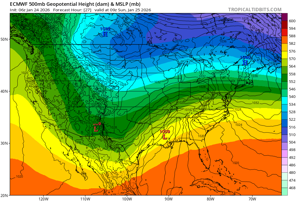
This image shows a depiction of the 500 mb height pattern across the U.S. early Sunday morning based on the 06Z Saturday ECMWF model guidance. Image courtesy of Tropical Tidbits.
As these systems try to phase together, rich moisture from the very warm Gulf of America will get pushed northeastward into the Arctic air mass that will be established across the Central Appalachian region This will lead to a widespread significant winter storm with heavy snow for many areas.
When Is The Upcoming Winter Storm Expected To Start And End?
While there still remains some uncertainty regarding the exact start time for the upcoming winter storm. Snow is beginning to push into the region from the west as of Saturday evening. As expected, there is some dry air that is initially hindering the moisture from reaching the surface. As we head into the overnight hours, the air will begin to become more saturated, resulting in snow reaching the ground and increasing in intensity.
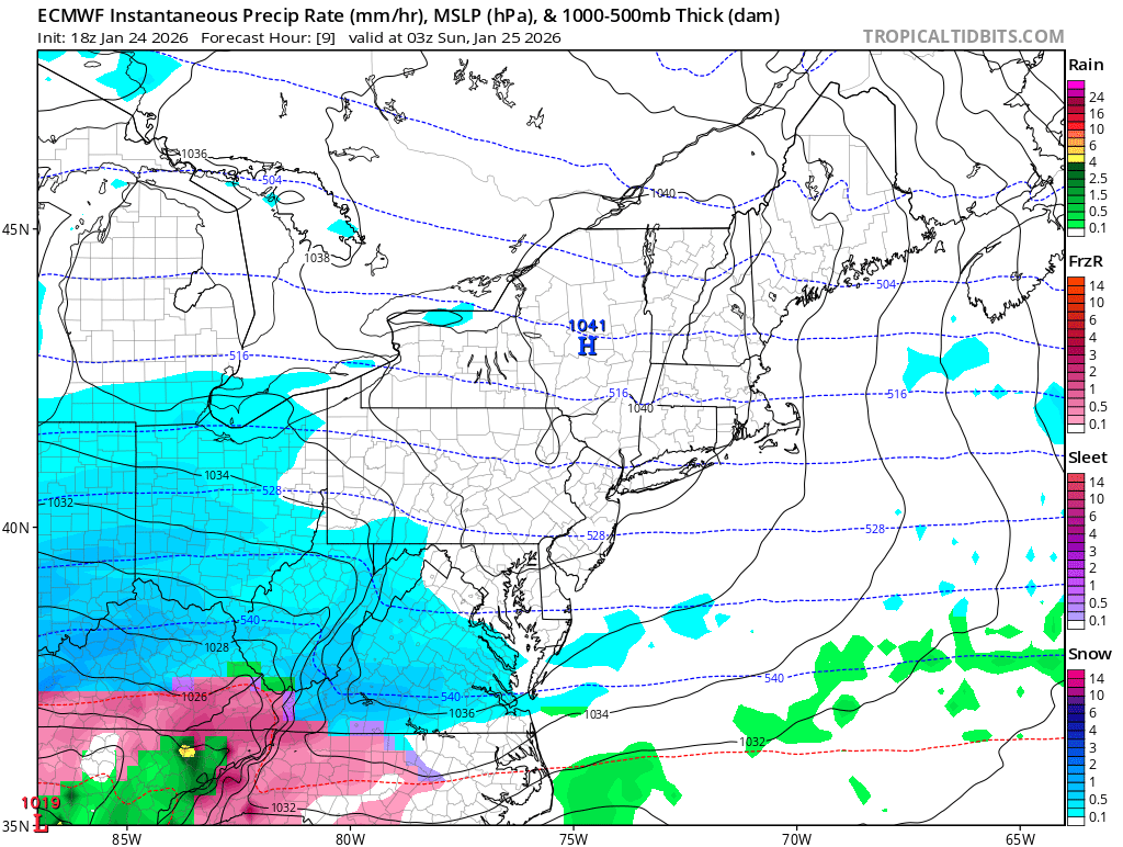
The image above shows a depiction of the 18Z Saturday ECMWF surface reflectivity as snow begins to move into the region Saturday evening. Image courtesy of Tropical Tidbits. .
The snow will fall heavily at times through the day on Sunday and begin to taper off overnight and into Monday morning. It is possible that some northwest flow light snow showers may continue into the day on Monday, but this snowfall would be much less impactful.
The image above shows a depiction of the 18Z Saturday ECMWF surface reflectivity as the snow exits the region Sunday night. Image courtesy of Tropical Tidbits.
How Much Snow Is Expected To Fall With The Upcoming Winter Storm?
Now it is time for the section of the blog that everyone wants to see the most. The National Weather Service has issued a Winter Storm Warning for the entire Central Appalachian region for the upcoming powerful winter storm. At this time, it appears that significant snowfall is likely to fall in many areas of the region.

The image above shows a depiction of the 12Z Saturday ECMWF surface reflectivity across the area on Sunday afternoon. Image courtesy of Tropical Tidbits.
Heavy snowfall rates are likely across many areas through the day on Sunday as the rich Gulf moisture gets thrown into Arctic air entrenched across the region. With this in mind there are some areas that appear to be in a more favorable position to see a major/crippling snowstorm.
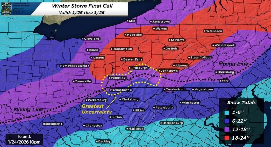
The map depiction above shows the currently expected snowfall totals form the upcoming winter storm.
Although some uncertainty still remains, it currently appears that there is going to be significant snowfall accumulation in many areas.
Here is a snowfall forecast range for several cities across the region:
- Youngstown, OH: 18-24 inches
- Du Bois, PA: 18-24 inches
- Warren, PA: 18-24 inches
- Harrisburg, PA: 12-18 inches
- State College, PA: 18-24 inches
- Zanesville, OH: 12-18 inches
- Washington, PA: 12-18 inches
- Hagertown, MD: 6-12 inches
- Morgantown, WV: 6-12 inches
- Charleston, WV: 6-12 inches
- Beckley, WV: 1-6 inches
It is important to emphasize that changes to the forecast snow totals could occur as the storm gets closer and model guidance converges on the eventual outcome.
Will There Be Any Mixed Precipitation Across The Region?
While the exact placement of the line between mixed precipitation and snow is uncertain, it is likely that a changeover to mixed precipitation will occur in West Virginia. Some model guidance would suggest that the nose of warm air could make it far enough north to cut down on snow totals southeast of Pittsburgh, but this is highly uncertain at this time. The most likely scenario at this time appears to favor mixed precipitation pushing north into northern West Virginia, and parts of southwestern PA (southeast of the Pittsburgh metro area).
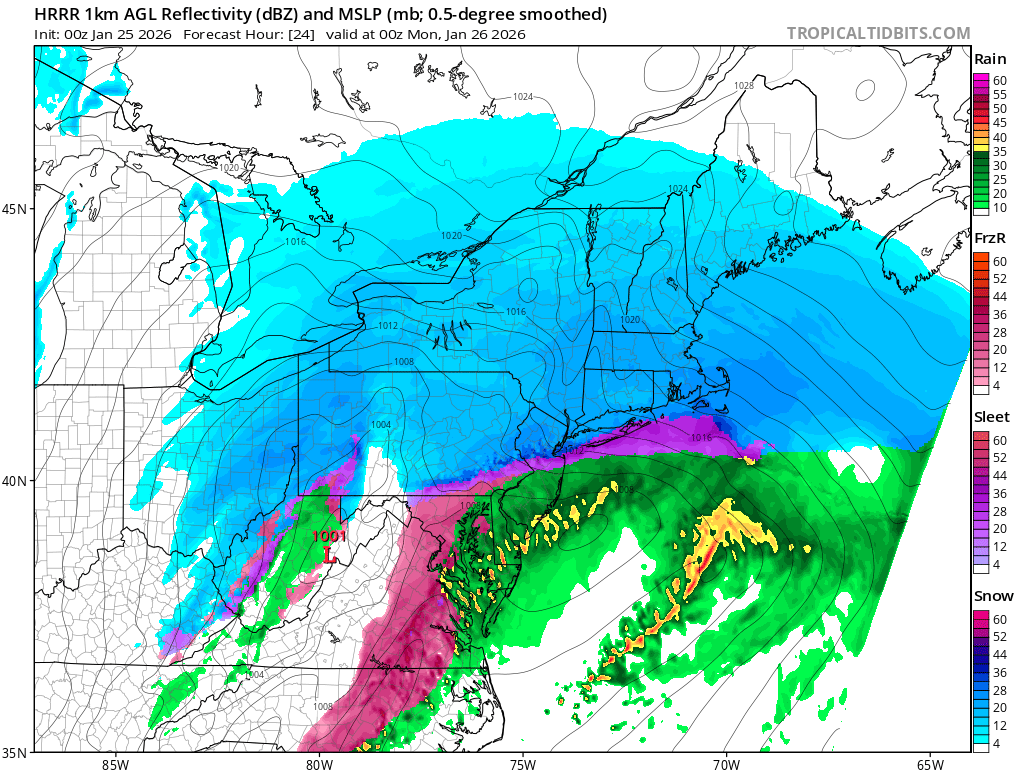
The image above shows the potential for mixed precipitation Sunday evening based on the 00z Sunday HRRR model guidance. Image courtesy of Tropical Tidbits..
Here is a list of cities across the region that will LIKELY experience mixed precipitation:
- Morgantown, WV
- Charleston, WV
- Uniontown, PA
- Harrisburg, PA
- Philadelphia, PA,
- York, PA
- Hagertown, MD
- Cumberland, MD
Here is a list of cities that MAY experience mixed precipitation:
- Greensburg, PA
- Washington, PA
- Washington, PA
- Altoona, PA
- Allentown, PA
- Somerset, PA
- Bedford, PA
The eventual location of the warm nose will determine the extent of mixed precipitation, and could have major implications on where the highest snow totals set up across the region.
Additional resources for additional information:
Leave a Reply to Troy Wilson Cancel reply