

NWS Alert Ticker v2.3 — CAWA Coverage • Smart Pulse • Zone Descriptors
Live NWS Watches & Warnings


Author: Troy Wilson

  • What Is El Nino, And How Does It Affect Our Weather?

    What Is El Nino, And How Does It Affect Our Weather?

    By now, many of you have probably heard many conversations in the news or on social media regarding El Nino. The National Oceanic and Atmospheric Administration (NOAA) is expecting the development of El Nino this summer, and it will likely strengthen as we head into the fall and winter. Social media is saturated with people trying to spread hype and fear over weather events like El Nino. While El Nino certainly impacts our weather in certain ways, there is no reason to become anxious about the weather over the next several months. In this blog, we will bring some clarity to the subject of El Nino, and discuss some of the ways that it could impact our weather in the coming months. We will also briefly discuss the impacts that it could have on our weather in the upcoming winter as well.

    Some topics we will discuss in this blog include:

    • What is El Nino?
    • How Does El Nino Affect The Jet Stream? 
    • What Atmospheric And Oceanic  Conditions Allow For The Formation of Tropical Systems?
    • How Does El Nino Impact The Hurricane Season?
    • How Does El Nino Affect Winter Weather? 

    What is El Nino?

    Before we discuss El Nino, let’s take a moment to talk about the El Nino Southern Oscillation Index (ENSO). ENSO is nothing more than a measurement of the sea surface temperatures (SST) in the equatorial eastern Pacific. The ENSO has two primary phases that oscillate depending on the strength of the trade winds. The cold phase of ENSO is classified as a La Nina. 
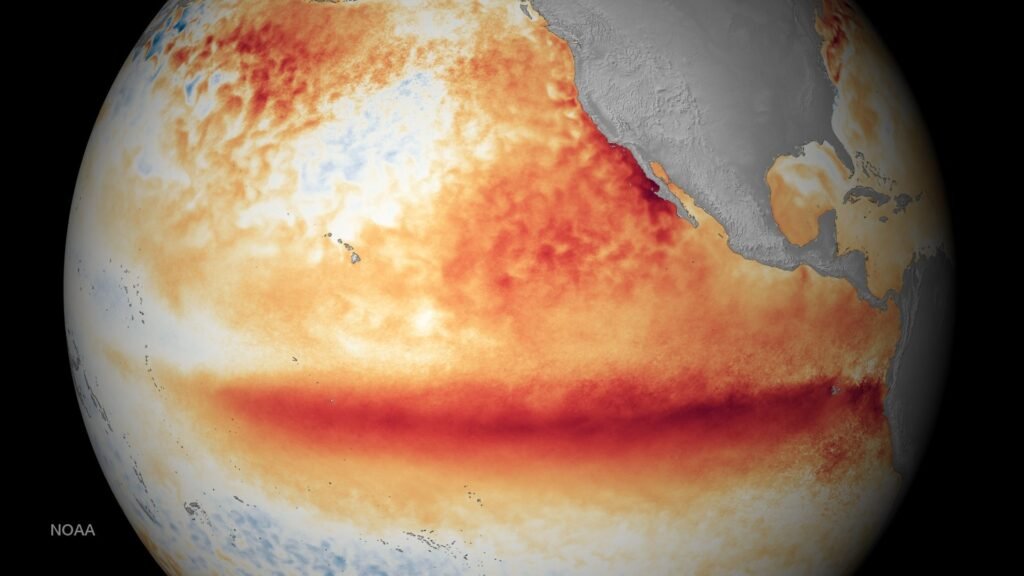
    This image shows a depiction of the warm eastern Pacific SST as a result of the 2015 El Nino. Image courtesy of NOAA

    This phase is observed when SST drop to 0.5 degrees below average or lower for three consecutive months in the Nino 3.4 region. On the other hand, the warm phase of the ENSO is classified as El Nino. El Nino occurs when SST in the Nino 3.4 region rise to 0.5 degrees or higher for three consecutive months.
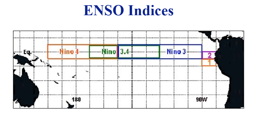
    Image above shows a depiction of various ENSO regions in the eastern Pacific Ocean. NOAA defines the Enso phase based on the SSST in the Nino 3.4 region. Image courtesy of National Weather Service

    How Does El Nino Affect The Jet Stream?

    There are two primary jet streams that affect the weather around the globe. The first is the Polar jet stream. In the Northern Hemisphere, this is the northern branch of the jet stream that helps to transport cold Arctic air southward toward the mid-latitudes. In contrast, the Subtropical Jet helps to transport moisture across the mid-latitudes. When the sun heats the surface of the tropics, it causes air parcels to rise and move north or south. Once the air cools, it begins to sink back down. These circulations of air are known as the Hadley cells. The subtropical jet forms high up in the atmosphere near the northern edge of the Hadley Cell in the Northern Hemisphere (around 30 degrees N). This moisture is then transported eastward. That is why the southern branch of the jet stream  is more active during El Nino. The warm water near the equatorial Pacific provides the moisture that eventually gets transported by the Subtropical Jet. 
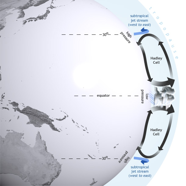
    This image shows how the Hadley Cells and Subtropical Jet combine to transport moisture northward toward the mid-latitudes. Image courtesy of National Oceanic And Atmospheric Administration

    If the northern branch of the jet stream becomes amplified, the two branches can phase, causing large mid-latitude cyclones. During El Nino, the Subtropical Jet strengthens as a result of the warm water in the equatorial Pacific Ocean. This warm water helps to initiate convection that is transported eastward with the Subtropical Jet Stream. In contrast, stronger flow in the Polar Jet tends to remain further to the north. While the effects of El Nino may be felt during the summer months, its impacts are much greater during the winter. 

    What Atmospheric And Oceanic Conditions Allow For The Formation of Tropical Systems?

    As we have already discussed, El Nino often results in an active Subtropical Jet. Because tropical systems often form in the subtropical regions of the Atlantic and Pacific Ocean, the presence of El Nino can directly impact tropical weather. As we enter the start of hurricane season, there are a couple of important notes regarding El Nino’s impacts. 

    Before we continue our discussion, let’s talk about how tropical systems form, and the type of environment that is necessary for them to strengthen into hurricanes. Tropical systems generally need SST of at least 80 degrees Fahrenheit, moist mid levels of the atmosphere, and unstable air in order for development to occur. In the eastern Atlantic Ocean, tropical systems often form as a result of waves of low pressure that are transported westward by the trade winds. This region is often known as the InterTropical Convergence Zone. In this region, warm water can lead to robust convection that results in tropical cyclone development. Similar to the Atlantic, tropical development in the eastern Pacific is often due to moisture transported by trade winds. Another factor that can cause tropical development is the Central American gyre. This area of low pressure can help form low pressure systems in the Caribbean Sea.  These systems often move northward toward the United States or westward through Mexico and the eastern Pacific

    How Does El Nino Impact The Hurricane Season?

    Now that we have established some of the ways that tropical systems develop, let’s discuss how El Nino can impact these systems. Due to the active Subtropical Jet pushing eastward toward the Atlantic Ocean, the hurricane season in this region is often hindered by increased wind shear in the upper levels of the atmosphere. The development of tropical systems requires high pressure and divergent winds in the upper levels of the atmosphere. This helps to enhance vertical growth and air ventilation. While El Nino often leads to a less active tropical season in the Atlantic, it is important to remember that tropical systems can still occur and deliver substantial impacts.

    Unlike the Atlantic Basin, the eastern Pacific often sees a more active hurricane season. Wind shear created by the Subtropical Jet can negatively influence tropical activity in the Atlantic; however, the affects of this wind shear are typically not as prevalent in the eastern Pacific. This is because high pressure is normally more prevalent further west in the equatorial Pacific during El Nino. As a result, upper level winds tend to be more conducive for tropical development in this region. 

    How Does El Nino Affect Winter Weather?

    An active Subtropical Jet has major implications for the winter weather pattern across North America. During an El Nino, the Polar branch of the jet stream tends to remain further north into Canada, which helps to bottle up Arctic air to the north of the continental U.S. This often leads to warmer than average temperatures and below average snowfall across the northern United States. Across the southern United States, El Nino typically leads to a cooler and wetter than average winter due to increased moisture in this area. 
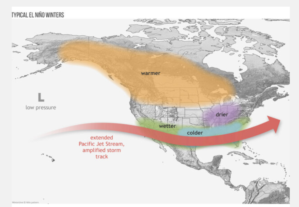
    The image above shows the typical winter jet stream pattern that is represented during El Nino. Image courtesy of Cclimate.gov

    It is also important to note that the strength of El Nino is important. If El Nino becomes strong, it is more likely to become the main component that drives the jet stream pattern. If El Nino remains weak; however, other teleconnections can override El Nino and provide a different outcome. 
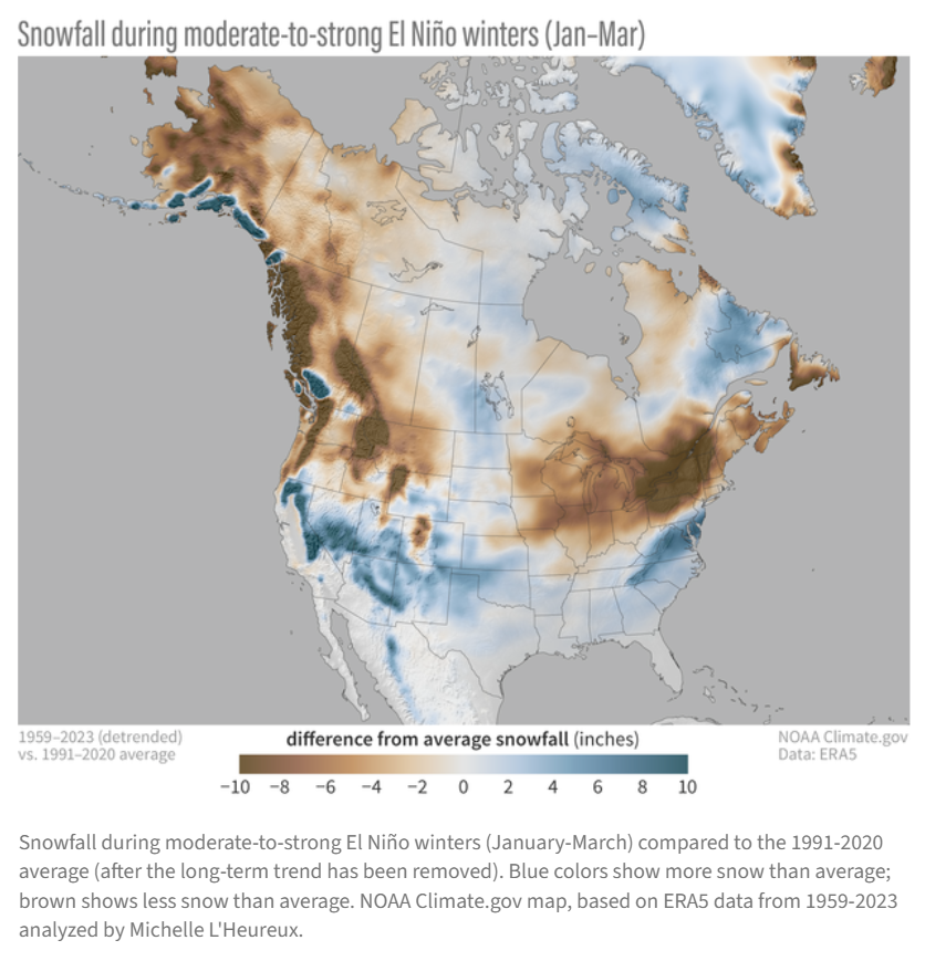
    Image courtesy of Climate.gov

    While the current forecast suggests a strong El Nino is likely during the 2026-27 winter season, it is far too early to determine an outcome for next winter. This is simply a sample of what past analogs suggest regarding a typical El NIno. 

    Other teleconnections that can affect the winter pattern include:

    While El Nino winters are typically notorious for fewer cold air outbreaks across the United States, cold air outbreaks and large winter storms can still occur. Changes in other atmospheric features such as the Polar Vortex can also play a role in our winter weather pattern. 

    The Bottom Line

    The main takeaway is that a strong El Nino is currently expected to occur in the coming months across the eastern Pacific Ocean, and it could have substantial impacts on our local weather, not only this summer, but also as we head into the fall/winter. 

    For additional resources regarding El Nino, please refer to the Climate Prediction Center. 
    https://www.cpc.ncep.noaa.gov/products/analysis_monitoring/lanina/enso_evolution-status-fcsts-web.pdf

  • Memorial Day Weekend Forecast!!

    Memorial Day Weekend Forecast!!

    As we enter the upcoming holiday, you are probably interested in how the weather will affect your outdoor picnics and festivities. Here is a look at what is expected at this point in time:

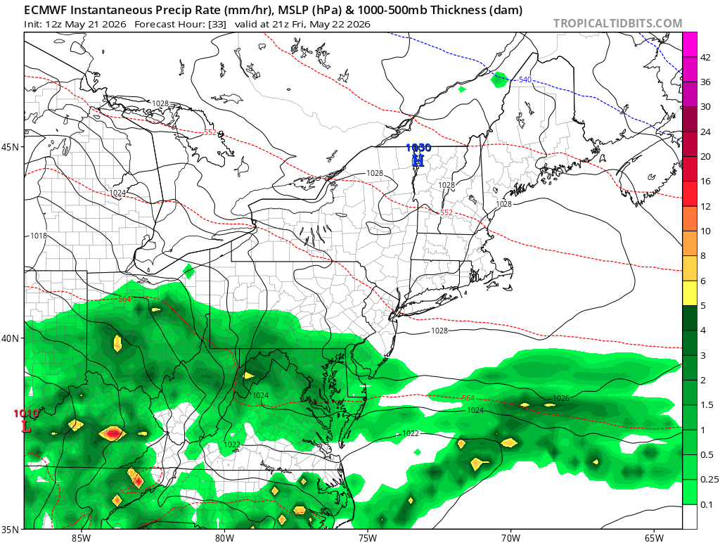
    Friday Forecast: Rain Arrives Throughout The Day 
    Rain will likely overspread the region from south to north throughout the day. Areas south of the PA Turnpike could see rain before noon, while locations north of I-80 may not see rain until the evening hours. Expect high temperatures in the 60s for most locations, with 50s anticipated in the higher elevations from eastern West Virginia to southwest/southcentral Pennsylvania.
    The image above shows a depiction of the surface reflectivity on Friday afternoon based on 12z Thursday ECMWF model guidance. Image courtesy of Tropical Tidbits

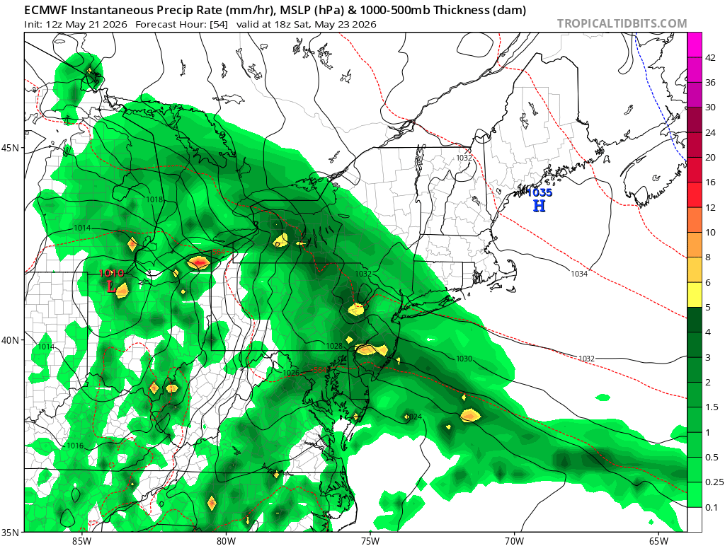
    Saturday Forecast: Improvement Likely Throughout The Day

    Steady rain is expected to come to an end from southwest to northeast throughout the morning and early afternoon hours; however, scattered showers are likely to persist the remainder of the day. At this point it looks as though the heaviest rainfall totals could occur across Ohio and northwest Pennsylvania, but this could certainty change. 

    The image above shows a depiction of the surface reflectivity on Saturday afternoon based on 12z Thursday ECMWF model guidance. Image courtesy of Tropical Tidbits

    Heavy rain could also occur with any thunderstorms that can form in Ohio. Expect high temperatures to range from near 70 in Ohio to the rain-cooled 40s in central Pennsylvania.

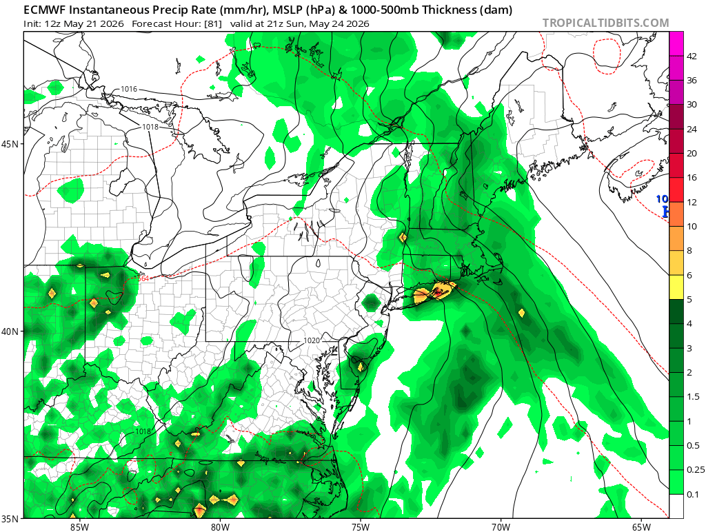
    Sunday Forecast: A Mainly Dry Day For Some. A Chance of Rain For Others

    Sunday will likely feature lower rain chances compared to Saturday. Much of eastern Ohio, Maryland, and western/central Pennsylvania will likely see a mainly dry day with the exception of a few showers. 

    The image above shows a depiction of the surface reflectivity on Sunday afternoon based on 12z Thursday ECMWF model guidance. Image courtesy of Tropical Tidbits

    Areas in West Virginia are more likely to see some showers and possibly a thunderstorm Sunday afternoon/evening. Expect highs to range from the 70s across Ohio, western Pennsylvania, Maryland, and West Virginia to the 60s across most of central Pennsylvania.

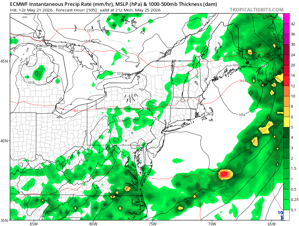
    Memorial Day Forecast: Mainly Dry For Most. An Isolated Shower or Storm Possible

    Memorial Day: Monday appears to be a mainly dry day for many locations in our region. A pop-up shower or storm may occur in a few locations, but most locations should see mainly dry conditions throughout the day. At this point, it appears that southern areas would have the best chance of seeing wet weather. Expect high temperatures in the 70s in most areas.

    The image shown above shows a depiction of the surface reflectivity on Monday afternoon based on 12z Thursday ECMWF model guidance. Image courtesy of Tropical Tidbits

    Expected Rainfall Totals Through Memorial Day

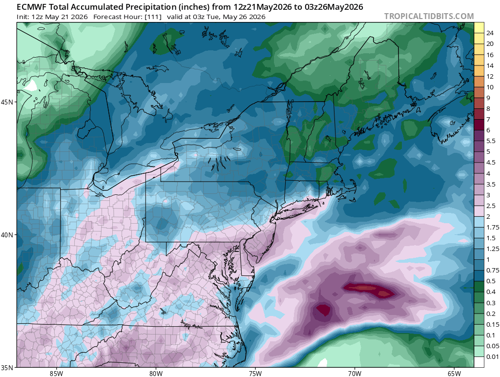
    While all areas of our region will see rainfall through Memorial Day, some locations will likely see more than others. The determining factor for which regions see the highest rainfall totals will be the location of a high pressure system over New England and a surface area of low pressure tracking through the Ohio Valley. 

    The image above shows a depiction of expected total precipitation through late Monday night based on 12z Thursday ECMWF guidance. Image courtesy of Tropical Tidbits

    At this point, it appears that Ohio, West Virginia, Maryland, and southcentral Pennsylvania may see the highest amounts with totals of 1.5 to 2.5 inches, while western and northern Pennsylvania may see totals closer to the 1-1.5 inch range. 

    While this summary gives a general idea of what is currently expected, keep in mind that this forecast will likely change over the next couple of days.

    Refer to the following resources for additional information:

  • Severe Weather Possible Late This Week!!!

    Severe Weather Possible Late This Week!!!

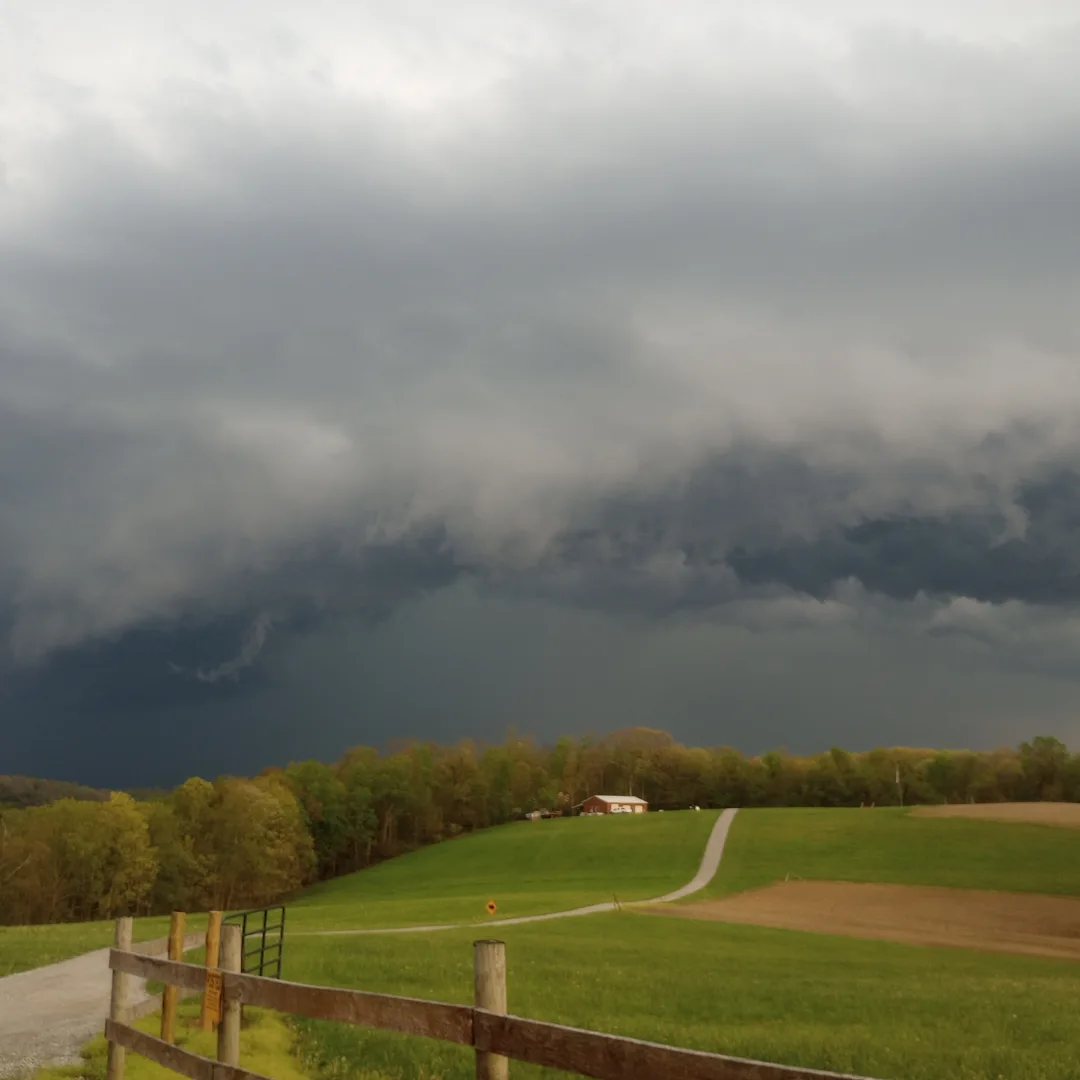
    Our active start to severe weather season is likely to continue later this week as a shortwave and associated cold front dive southeast toward the Ohio Valley on Thursday. At this time, it appears that damaging winds and large/very large hail would be the primary threat, but isolated tornadoes may also be possible. Considering the moist low level flow and parallel boundary storm motion, flash flooding may also be a concern. 

    Some of the key highlights that we will cover in this blog include: 

    • Meteorological Setup for severe weather
    • Expected storm mode and severe weather hazards
    • Timing and Areas of greatest risk 

    While forecasting severe weather days in advance can be challenging, this blog will discuss some possible outcomes. 

    Meteorological Setup For Severe Weather 

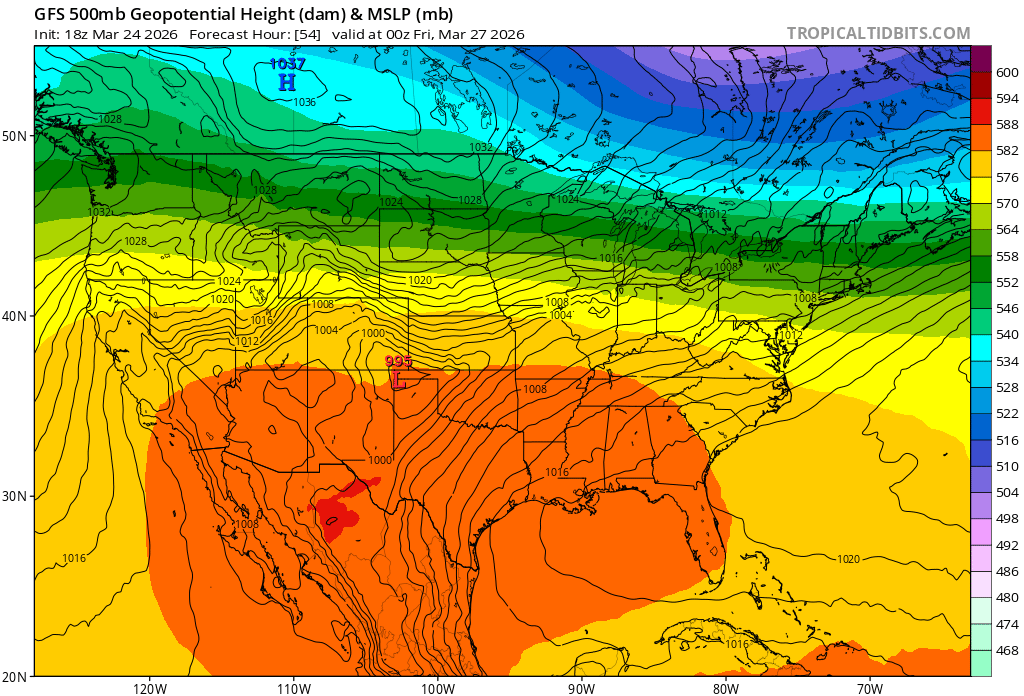
    An unusually strong early spring ridge of high pressure will continue to bring very warm weather to the central Plains over the next several days. At the same time a shortwave diving southeastward from the Northern Plains will push a cold front toward the Ohio Valley and Central Appalachian region on Thursday. An area of high pressure that is currently situated over the eastern United States will move off the eastern seaboard as we head toward mid-week. Clockwise motion around the retreating high pressure system will help to return Gulf moisture into the region ahead of the approaching cold front. This will set the stage for the potential severe weather episode across our region. 

    The image above shows the 500 mb pattern on Thursday based on 18z Tuesday GFS model guidance. Image courtesy of Tropical Tidbits

    Ahead of this system, a moist flow will develop, helping to provide the surface moisture needed for severe weather. In addition to the sufficient low level moisture, it is also likely that there will be strong speed shear present. If lapse rates become steep enough to overcome a capping inversion, there is the potential for supercell storms to produce large/very large hail and damaging winds. While the potential is relatively low at this time, it is possible that there could be a couple of tornadoes if there is enough low level moisture and low level directional wind shear available. At this time, it appears that eastern Ohio may be the most favored area for severe weather in our area, but all locations should be prepared for the potential of severe weather late Thursday into Thursday night. 

    Expected Storm Mode And Severe Weather Hazards

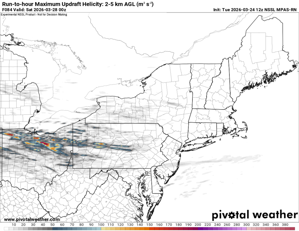
    Due to the steep lapse rates aloft and somewhat limited surface-based instability, it is likely that an elevated storm mode will be most dominant. With that being said, it is possible the low level moisture, combined with lower lifted condensational level (LCLs), will be sufficient to support a few surface-based supercells with a tornado potential. Otherwise, adequate speed shear aloft will likely lead to elevated supercells capable of producing downburst winds and large hail. It is possible that very large hail may occur if instability is high enough to support strong updrafts.

    The image above shows a depiction of the 2-5 km updraft helicity for Thursday’s event based on 12z Tuesday NSSL MPAS-RN model guidance. Image courtesy of Pivotal Weather

    If surface winds are too parallel to the boundary, it is possible that the storms may quickly form into a convective line. In addition to the severe weather potential parallel boundary winds may lead to storms training over the same areas multiple times. Given the expectation for elevated dewpoints, it is possible that some instances of flash flooding may occur, especially in areas that experienced heavy rainfall on Sunday. 

    Timing And Areas of Greatest Risk 

    At this point in time, model guidance would suggest that Ohio may have the greatest risk for severe weather due to better moisture and more optimal timing of the storms. With this in mind, sufficient ingredients for severe weather may be in place across the entire region and future model guidance should be monitored for potential eastward shifts in the risk area. 

    The image above shows a depiction of the surface reflectivity on Thursday evening based on 12z Tuesday NSSL MPAS-RN model guidance. Image courtesy of Pivotal Weather

    The most likely timeframe for severe weather will depend on a couple of factors. The first factor will be dependent on prefrontal supercell initiation and the other will be the eventual speed and progression of the system. While it is too early to forecast the exact timing of storm arrival, it currently appears that storms would arrive across northern Ohio during the late afternoon/evening and progress southeastward toward the rest of the region through the rest of the evening/early overnight hours. As would be expected, a later arrival of the system would likely somewhat decrease the risk of severe weather in our area. 

    As always, the details regarding the potential for severe weather timing, location, and impacts will become more clear as the event approaches and CAM’s can better sample the atmospheric ingredients.

  • Strong Storm System To Affect The Region On Monday!!!

    Strong Storm System To Affect The Region On Monday!!!

    A powerful early spring low pressure system will develop in the Plains and strengthen as it moves into the Great Lakes on Monday.

    Due to the rapidly strengthening storm and its neutral/negatively tilted trough, there will likely be very strong wind shear ahead of the cold front. While moisture return in the warm sector may be limited, it is possible that the strong kinematics may be sufficient to produce severe weather across parts of the region Monday afternoon.

    Some topics that we will discuss in this blog include: 

    • Meteorological Analysis of The Storm System
    • Potential Impacts From The Storm Across Our Area
    • Timing of the Front Is Important

    Now let’s dive into our discussion about the upcoming powerful storm system!

    Meteorological Analysis of The Storm System

    As we head into Sunday, a strong storm system will begin to develop across the central United States. As the storm begins to move northeast toward the Great Lakes, it is expected to intensify into a strong mid-latitude cyclone by Monday. The storm system will also begin to transition from a neutral to a negatively 500mb trough as this process occurs. 

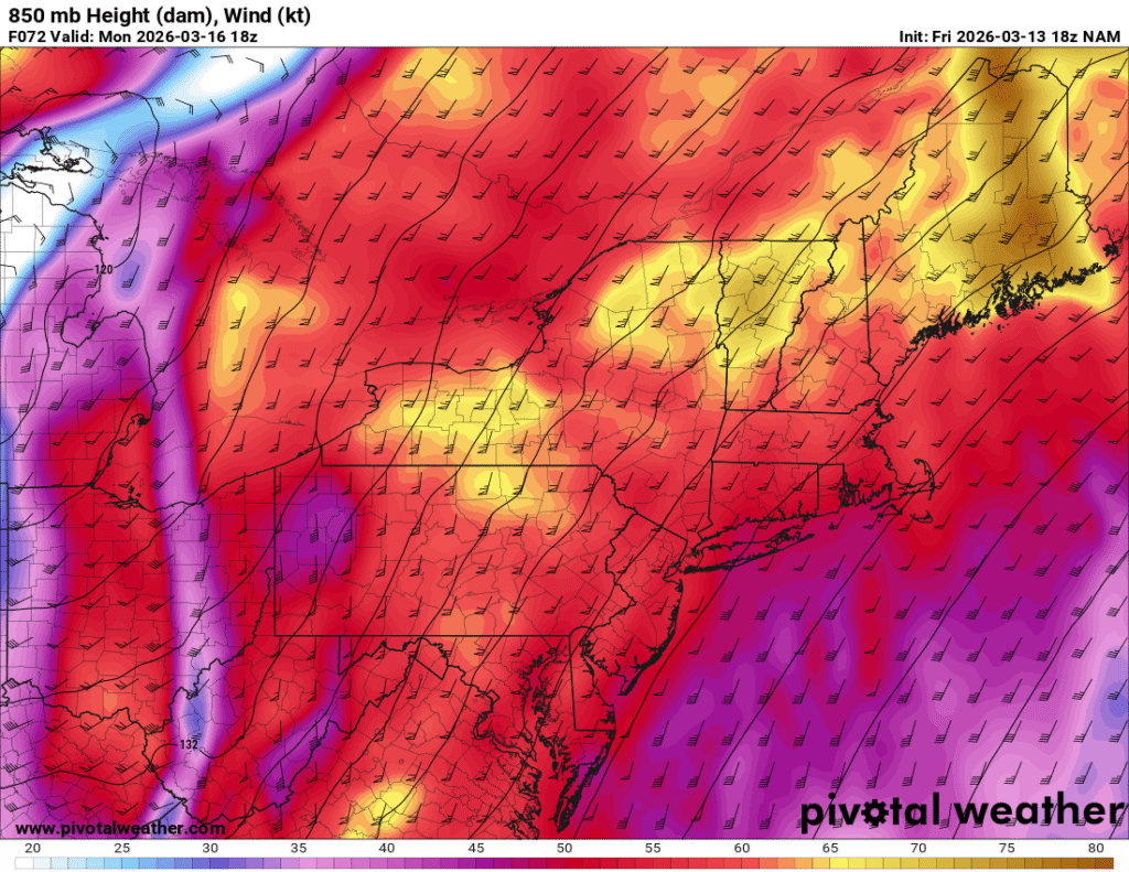
    The image above shows a depiction of the 850 mb jet winds across the area early Monday afternoon based on 18z NAM 12 km  model guidance. Image courtesy of Pivotal Weather

    This will result in a strong low level 850 mb jet streak that will develop across the Mississippi Valley on Sunday and move across the Ohio Valley, Mid-Atlantic and Northeast on Monday, leading to impactful and potentially damaging weather conditions across a wide swath of the central and eastern United States. 

    Potential Impacts From The Storm Across Our Area

    Due to the rapidly strengthening storm and its neutral/negatively tilted trough, there will likely be very strong wind shear ahead of the cold front. While moisture return in the warm sector may be limited, it is possible that the strong kinematics may be sufficient to produce severe weather across parts of the region Monday afternoon.

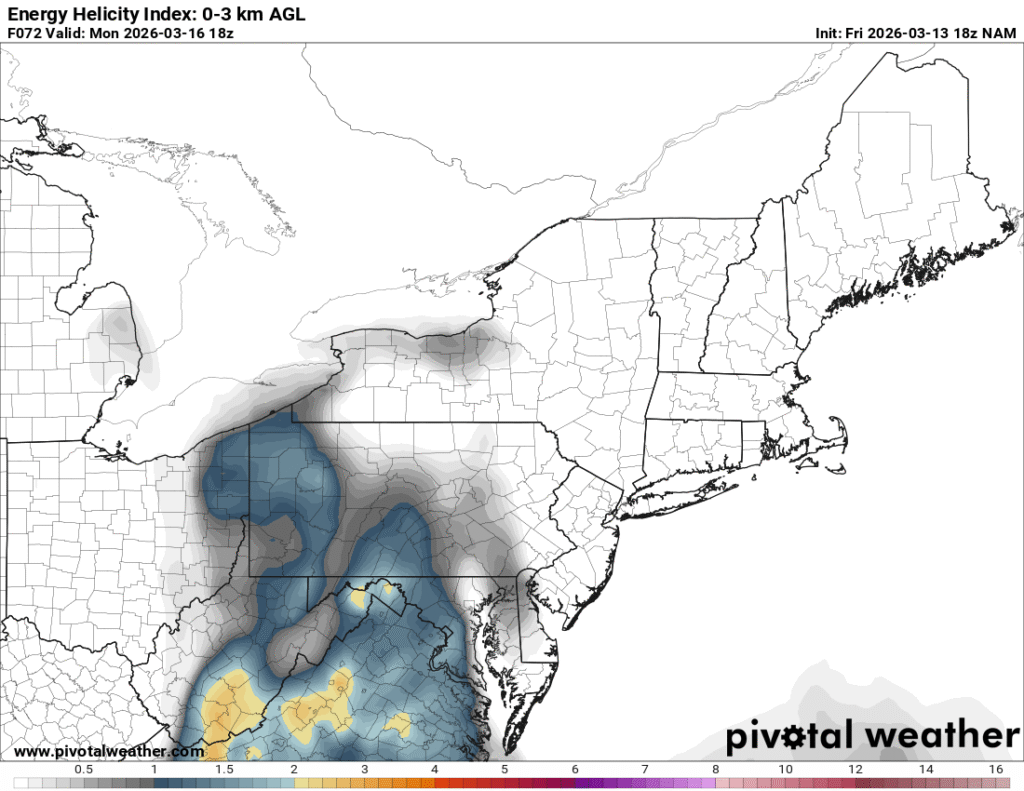
    The image above shows a depiction of the Energy Helicity Index (EHI) across the region early Monday afternoon based on 18z NAM 12km guidance. Image courtesy of Pivotal Weather

    While it is too early to analyze many of the convective allowing, high revolution model guidance, the pattern appears favorable for the potential for impactful damaging winds and potentially embedded tornadoes along the cold front. When analyzing the 18z NAM 12 km guidance, we can see that there is a decent Energy Helicity Index (EHI) across our region Monday afternoon. This parameter helps to determine where the best overlap of instability and wind shear are located. The severe weather potential will likely be most prevalent in the area where the EHI is at its maximum. If sufficient moisture returns ahead of the front occurs, it is possible that a few discrete supercellular storms could develop as well. At this time, this idea appears unlikely across most of our area. 

    Timing of The Front Is Important 

    The timing of the front will be important. If the system is slower to arrive, the potential for severe weather would increase across many areas. A frontal passage that occurs during the morning hours would not allow for much surface heating and destabilization to occur prior to the passage of the cold front; whereas, an afternoon frontal passage would allow for a heightened severe weather potential, resulting from stronger updrafts. Even if the timing of the front is not favorable for severe weather, it is possible that a line of strong to damaging winds will still occur, given the strong low level jet that will be moving through the region.

    It is important to emphasize that the potential impacts from this storm system are still two to three days away, and changes to the forecast will certainly occur over the next couple of days. 

  • How Much Severe Weather Will We Have This Spring?

    How Much Severe Weather Will We Have This Spring?

    As we approach the end of winter, many people are looking forward to the return of warmer weather in the coming weeks. While the approach of spring is a welcoming thought following a cold winter, spring time can also bring with it the potential for severe weather episodes that deliver damaging winds, large hail, and tornadoes. While severe weather is complicated, there are four primary ingredients that are necessary for the development of severe weather.

    These ingredients include: 

    • Shear: Wind shear measures the amount of change in wind speed and direction through the atmosphere. 
    • Lift: The amount of positive buoyancy (or upward motion) available for air parcels to rise and form clouds and precipitation. 
    • Instability: Instability or convective available potential energy (CAPE) refers to the amount of energy that is available for the atmosphere to produce thunderstorms. 
    • Moisture: Warm, moist air rises to the lifting condensation level (LCL) where condensation occurs. Strong upward motion can then lead to tall convective thunderstorms that can produce severe weather. 

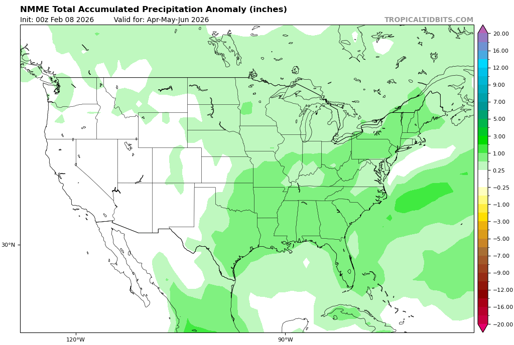
    The image above shows a depiction of the precipitation pattern for the spring based on the NNME model guidance. Image courtesy of Tropical Tidbits

    The availability of these ingredients will largely depend on the jet stream pattern that develops across the United States as we approach spring. If the jet stream sets up in a wavy pattern, the number of severe weather opportunities will likely increase as systems bring in the warm, moist air and wind shear needed for severe weather development. 

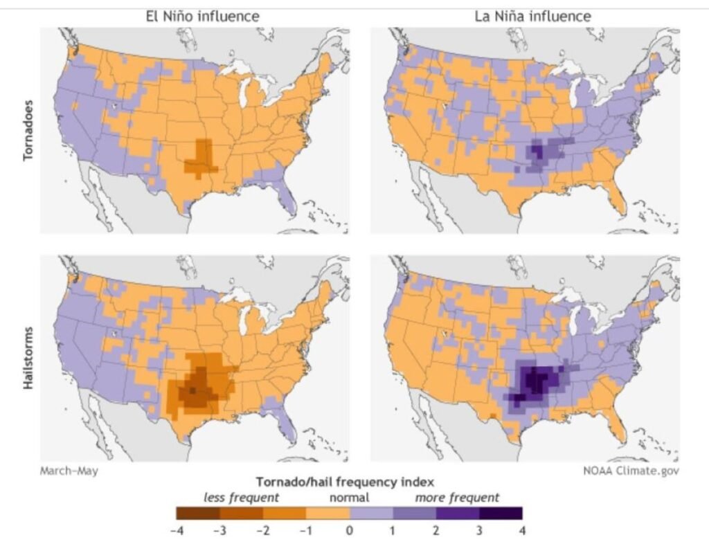
    How Does ENSO Affect Severe Weather?

    The persistence of an active severe weather pattern into late spring and early summer will likely depend on how quickly El Nino develops in the equatorial Pacific Ocean. A quicker transition to El Nino would favor a decrease in severe weather, while a continuation of El Nino Southern Oscillation (ENSO) neutral conditions could lead to severe weather continuing into the summer. 

    The images above show a depiction of tornado and hail frequency associated with positive and negative ENSO conditions. Image courtesy of National Oceanic and Atmospheric Administration (NOAA).

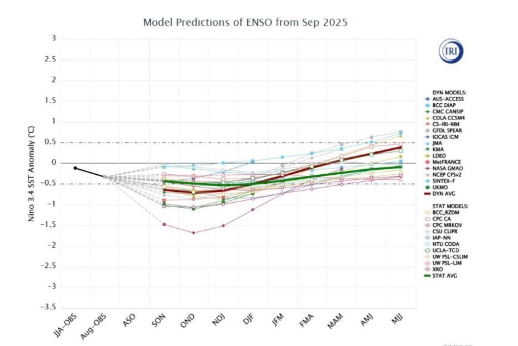
    Through much of the winter season, La Nina conditions have been observed in the equatorial Pacific. With that in mind, La Nina has begun to weaken in recent weeks and is likely to progress to neutral condition this Spring. An eventual transition to EL Nino appears likely during the summer or fall season of 2026.

    The image above shows the ENSO forecast based on guidance from various long range forecast models. Image courtesy of the National Weather Service.

    The Big Picture

    While uncertainties exist in any long range forecast, the general consensus favors a fairly active severe weather season with near to above average severe weather observation expected in the area. Now is the time to start thinking about severe weather safety so that you are prepared to protect your family and property during severe weather. 

    It is important to note that uncertainties still remain in the frequency and intensity of severe weather during the upcoming spring, and this blog may be updated in the future to account for changes to the forecast. 

  • Major Winter Storm Expected This Weekend!!!

    Major Winter Storm Expected This Weekend!!!

    A major winter storm will bring significant snowfall to the region from Saturday night into Monday morning. Confidence continues to increase that there will be a substantial winter storm across the Central Appalachian region. While there are uncertainties regarding snowfall totals and precipitation type, the region should prepare for one of the most widespread impactful winter storms that has been observed since winter storm Jonas in 2016. 

    What We Know:

    • A significant winter storm will affect the region this weekend.
    • Some areas could measure snow in feet.
    • Arctic air will precede and follow the storm.
    • The combination of heavy snow, wind, and reduced visibility will make travel difficult or impossible. 

    What We Do Not Know:

    • The exact timing of the end of the storm
    • Exact snowfall totals
    • The location and amount of mixed precipitation in our area

    Some topics that we will cover in this blog include:

    • What Are The Meteorological Factors That Are Causing The Upcoming Winter Storm?
    • When Is The Upcoming Winter Storm Expected To Begin And End?
    • How Much Snow Is Expected To Fall With The Upcoming Winter Storm?
    • Will There Be Any Mixed Precipitation Across The Region?

    What Are The Meteorological Factors That Are Causing The Upcoming Winter Storm?

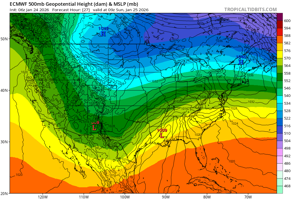
    There are three meteorological factors that are combining to create this massive winter storm. 

    1. The first factor is the presence of a strong Arctic high pressure system in Canada. This will funnel cold air southward ahead of the storm system. 
    2. The second factor is an upper level low pressure system that is moving northeast from the Southern Plains. This southern stream piece of energy is helping to supply rich moisture. 
    3. The third factor is a northern stream trough that is moving southeastward from the Northern Plains. This is the piece of energy that is steering the southern stream energy northeastward from the Southern Plains this weekend. 

    This image shows a depiction of the 500 mb height pattern across the U.S. early Sunday morning based on the 06Z Saturday ECMWF model guidance. Image courtesy of Tropical Tidbits.

    As these systems try to phase together, rich moisture from the very warm Gulf of America will get pushed northeastward into the Arctic air mass that will be established across the Central Appalachian region This will lead to a widespread significant winter storm with heavy snow for many areas.

    When Is The Upcoming Winter Storm Expected To Start And End?

    While there still remains some uncertainty regarding the exact start time for the upcoming winter storm. Snow is beginning to push into the region from the west as of Saturday evening. As expected, there is some dry air that is initially hindering the moisture from reaching the surface. As we head into the overnight hours, the air will begin to become more saturated, resulting in snow reaching the ground and increasing in intensity.

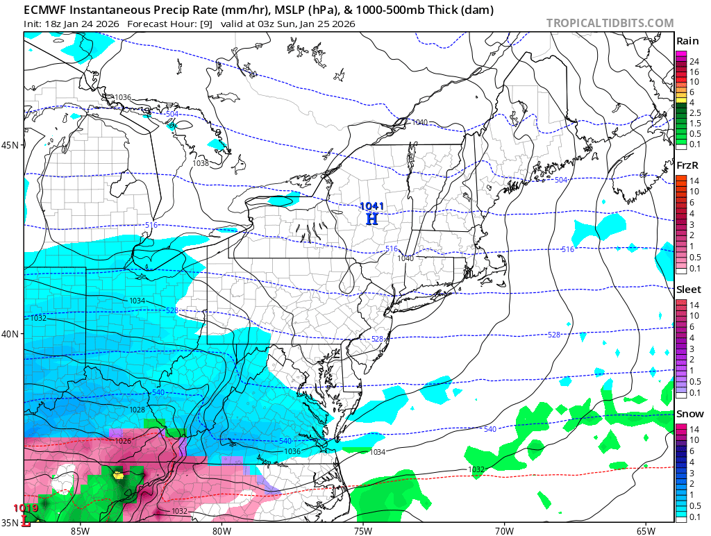
    The image above shows a depiction of the 18Z Saturday ECMWF surface reflectivity as snow begins to move into the region Saturday evening. Image courtesy of Tropical Tidbits. . 

    The snow will fall heavily at times through the day on Sunday and begin to taper off overnight and into Monday morning. It is possible that some northwest  flow light snow showers may continue into the day on Monday, but this snowfall would be much less impactful.

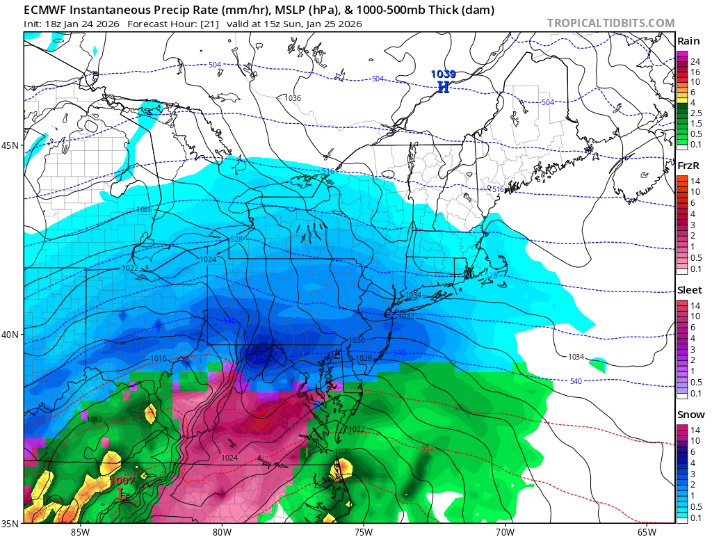
    The image above shows a depiction of the 18Z Saturday ECMWF surface reflectivity as the snow exits the region Sunday night. Image courtesy of Tropical Tidbits

    How Much Snow Is Expected To Fall With The Upcoming Winter Storm?

    Now it is time for the section of the blog that everyone wants to see the most. The National Weather Service has issued a Winter Storm Warning for the entire Central Appalachian region for the upcoming powerful winter storm. At this time, it appears that significant snowfall is likely to fall in many areas of the region. 

    The image above shows a depiction of the 12Z Saturday ECMWF surface reflectivity across the area on Sunday afternoon. Image courtesy of Tropical Tidbits

    Heavy snowfall rates are likely across many areas through the day on Sunday as the rich Gulf moisture gets thrown into Arctic air entrenched across the region. With this in mind there are some areas that appear to be in a more favorable position to see a major/crippling snowstorm. 

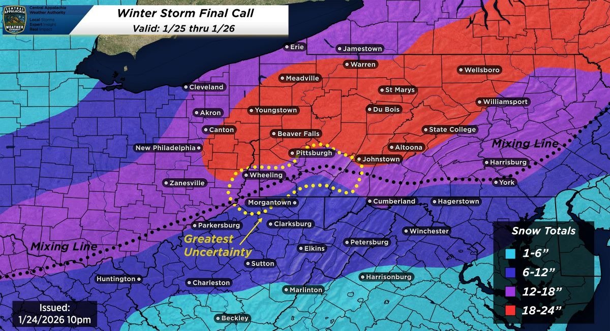
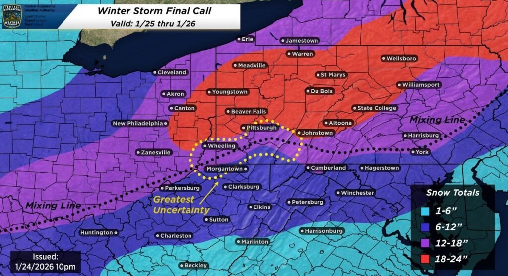
    The map depiction above shows the currently expected snowfall totals form the upcoming winter storm. 

    Although some uncertainty still remains, it currently appears that there is going to be significant snowfall accumulation in many areas.

    Here is a snowfall forecast range for several cities across the region:

    • Youngstown, OH: 18-24 inches
    • Du Bois, PA: 18-24 inches
    • Warren, PA: 18-24 inches
    • Harrisburg, PA: 12-18 inches 
    • State College, PA: 18-24 inches 
    • Zanesville, OH: 12-18 inches
    • Washington, PA: 12-18 inches
    • Hagertown, MD: 6-12 inches 
    • Morgantown, WV: 6-12 inches
    • Charleston, WV: 6-12 inches
    • Beckley, WV: 1-6 inches

    It is important to emphasize that changes to the forecast snow totals could occur as the storm gets closer and model guidance converges on the eventual outcome. 

    Will There Be Any Mixed Precipitation Across The Region?

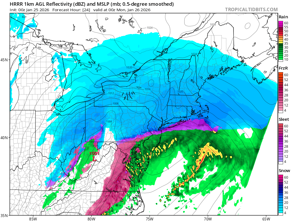
    While the exact placement of the line between mixed precipitation and snow is uncertain, it is likely that a changeover to mixed precipitation will occur in West Virginia. Some model guidance would suggest that the nose of warm air could make it far enough north to cut down on snow totals southeast of Pittsburgh, but this is highly uncertain at this time. The most likely scenario at this time appears to favor mixed precipitation pushing north into northern West Virginia, and parts of southwestern PA (southeast of the Pittsburgh metro area).

    The image above shows the potential for mixed precipitation Sunday evening based on the 00z Sunday HRRR model guidance. Image courtesy of Tropical Tidbits..

    Here is a list of cities across the region that will LIKELY experience mixed precipitation:

    • Morgantown, WV
    • Charleston, WV
    • Uniontown, PA
    • Harrisburg, PA
    • Philadelphia, PA, 
    • York, PA
    • Hagertown, MD
    • Cumberland, MD

    Here is a list of cities that MAY experience mixed precipitation:

    • Greensburg, PA 
    • Washington, PA 
    • Washington, PA
    • Altoona, PA 
    • Allentown, PA
    • Somerset, PA
    • Bedford, PA

    The eventual location of the warm nose will determine the extent of mixed precipitation, and could have major implications on where the highest snow totals set up across the region.

    Additional resources for additional information:

  • Impactful Winter Weather Is Expected Across the Central Appalachian Region Through Thursday

    A cold front will move across the Central Appalachian region this evening into the overnight, returning winter weather to much of the area. Impactful snow accumulation and frigid temperatures will be possible as Arctic air makes a return.

    Here are a few of the key highlights and impacts:

    • Rain will transition to snow Wednesday evening with the potential for a rapid freeze up.
    • Snow accumulations are likely for most areas along and west of the Allegheny Front From Wednesday evening through Thursday.
    • Snow squalls may lead to limited visibility and hazardous travel conditions on Thursday.

    Rain Will Transition To Snow Wednesday Night With The Potential For A Rapid Freezeup

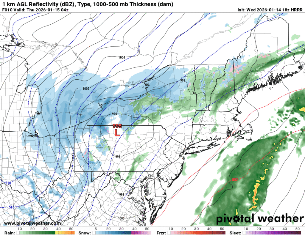
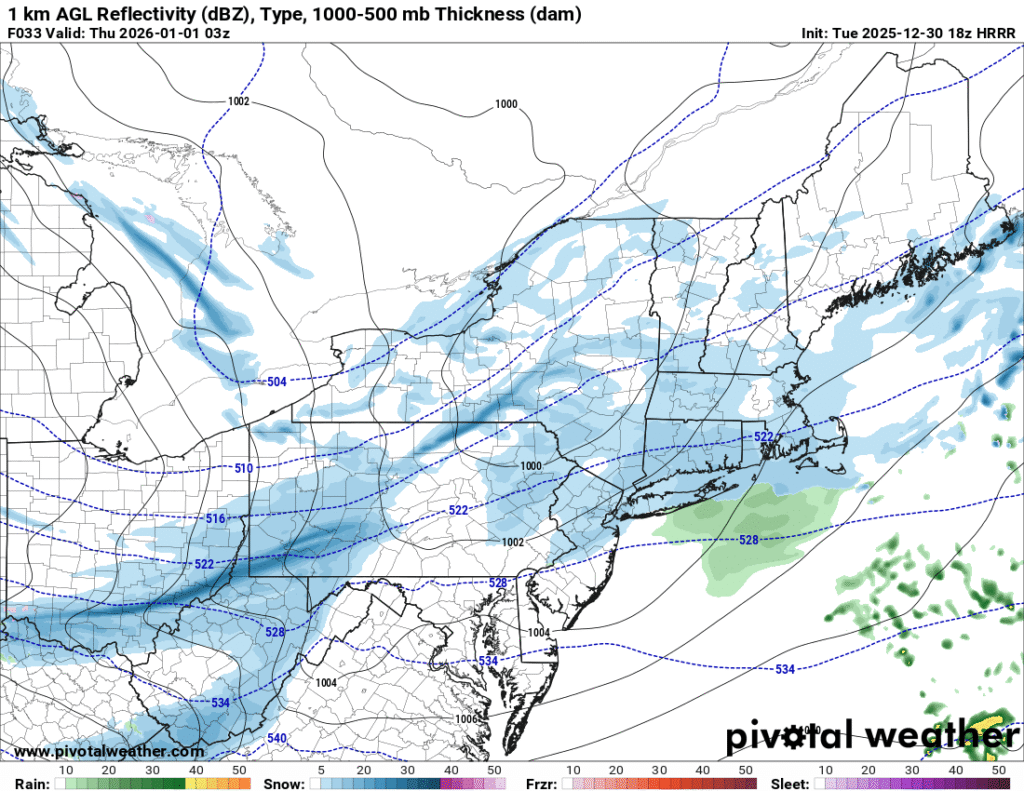
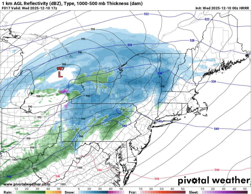
    As a strong cold front moves eastward through the region Wednesday night, Arctic air will begin to rapidly push into the region. The front will be accompanied by rain that will transition to snow with the arrival of the colder air. The combination of water on roadways and temperatures quickly falling below freezing could cause a rapid freeze up Wednesday evening into Wednesday night.

    This image shows a depiction of surface reflectivity across the region late Wednesday evening based on 18z HRRR model guidance. Image courtesy of Pivotal Weather.  

    Snow Accumulations Are Likely For Most Areas Along And West of The Allegheny Front From Wednesday Evening Through Thursday

    As the colder air arrives across the Central Appalachian region Wednesday evening, rain will transition to a period of snow. Warm surface temperatures may initially hinder snow accumulations at first, but snow will begin to accumulate on all surfaces through the night as below freezing temperatures move into the region. A quick accumulation of snow is likely Wednesday evening into the early overnight across many areas of eastern Ohio, northern West Virginia, and western PA before steady snow transitions to scattered snow showers through the remainder of the overnight hours. 

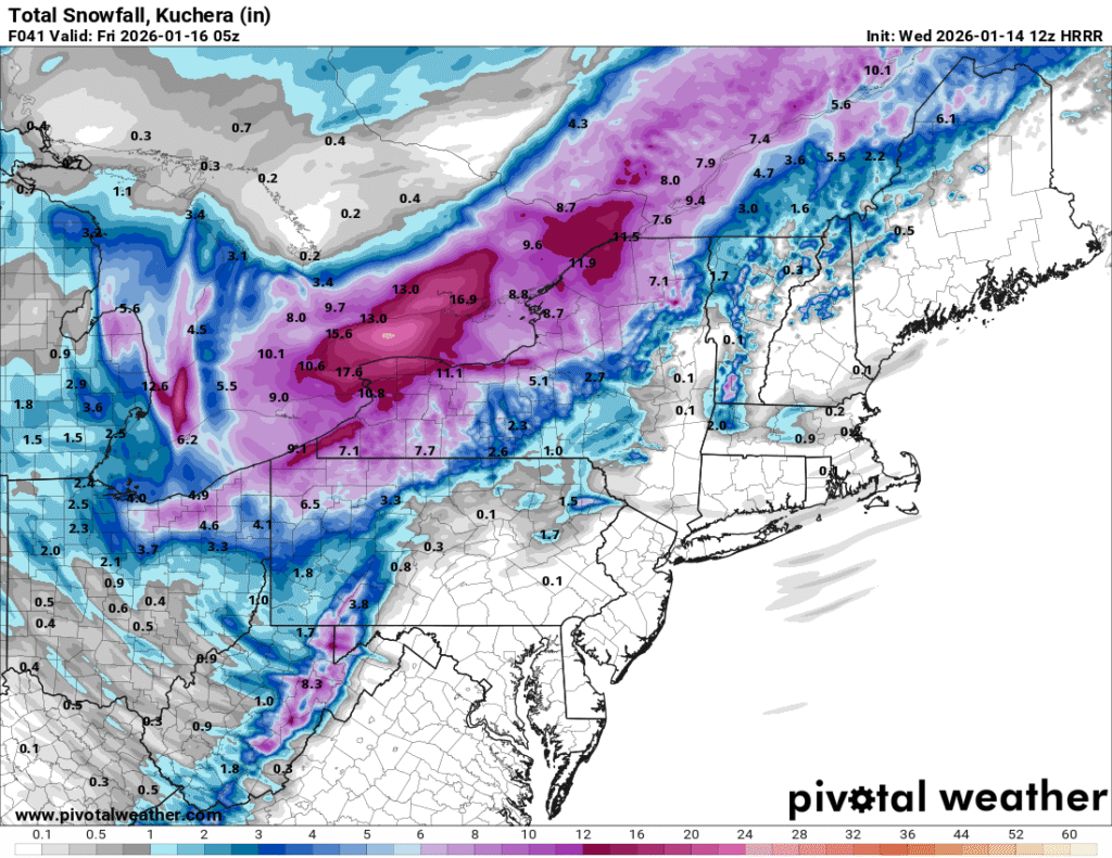
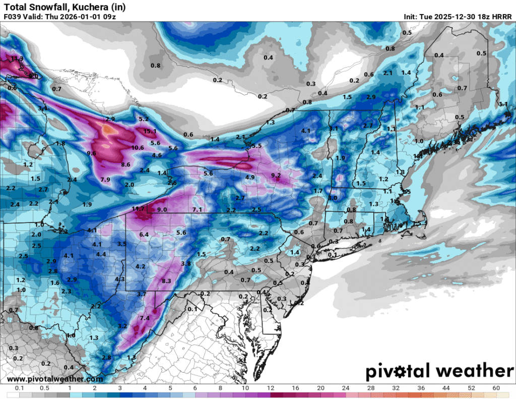
    The image above shows a depiction of expected snow accumulation through Thursday evening based on 18z HRRR model guidance. Image courtesy of Pivotal Weather

    Additional snow showers and squalls on Thursday will lead to additional light accumulations for many areas. A storm total of 1 to 3 inches of snow is likely for many areas in the lowlands of western PA, eastern Ohio and northern West Virginia that are south and west of Pittsburgh. Areas north and west of Pittsburgh will likely see 2 to 4 inches. The higher elevation of western Maryland, northern West Virginia, and southwest PA will likely see 3 to 6 inches of total accumulation with isolated higher amounts possible.. Areas from northeast Ohio into western New York will likely see a more extended period of steady snow leading to heavier accumulations in the 6 to 12 inch range. Lake effect snow on Thursday will also aid in higher accumulations in this area. It is possible that amounts may be higher or lower in some areas depending on how much moisture overlaps with cold air Wednesday evening into the overnight The intensity and coverage of upslope and lake effect snow on Thursday will also have implications on snow totals. 

    Snow Squalls May Lead to Limited Visibility And Hazardous Travel Conditions On Thursday

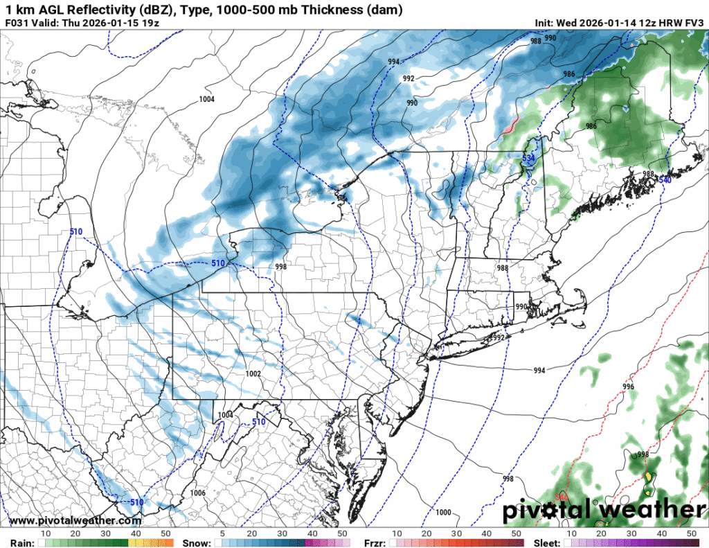
    As we move into the day on Thursday, there will be the potential for more snow showers and some snow squalls to develop for areas mainly along and west of the Allegheny Front. These snow squalls may be accompanied by heavy snow, limited visibility and gusty winds. Any heavy snow squalls that form can drop a quick light accumulation of snow in isolated areas. 

    The image above shows a depiction of the surface reflectivity on Thursday afternoon based on 12z HRW FV3 model guidance. Image courtesy of Pivotal Weather

    More persistent lake effect snow will also be ongoing on Thursday in the typical lake effect regions downwind of Lake Erie. If you plan to travel during the day on Thursday, be sure to heed any snow squall warnings and delay travel until the snow squalls have passed your location. 

    Additional resources for additional information:

  • New Year’s Eve Winter Storm Expected For The Central Appalachian Region

    While most of the region did not experience a white Chirtsmas, the same will not be said for New Year’s Day. Accumulating snow is expected for most areas across the region from Wednesday afternoon through Wednesday night as a winter storm moves into the region. 

    Some of the major impacts from the upcoming winter storm include: 

    • Light Snow Accumulation Possible With A Weak Disturbance Tonight.
    • Plowable Snow Expected For Areas Along And West of The Allegheny Front on New Year’s Eve
    • Snow Squalls Likely Across Much of The Region Late Wednesday. 

    Light Snow Accumulation Possible WIth A Weak DIsturbance Tonight

    Prior to the more substantial snow event expected Wednesday into Wednesday night, a weak weather disturbance will move southeast toward the region tonight bringing a quick chance for light accumulating snow for areas along and west of the Allegheny Front. A general coating to two inches is expected for most locations. 

    The image above shows the expected snow totals through 10 a.m. Wednesday, based on the HRRR model. Image courtesy of Pivotal Weather

    Plowable Snow Expected For Areas Along And West of The Allegheny Front New Year’s Eve

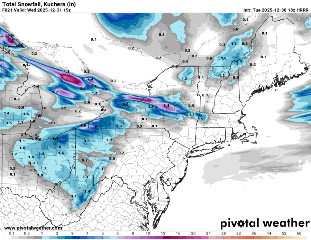
    As we head into the day on New Year’s Eve, a storm system will begin to approach the region from the northwest. During the afternoon, snow will begin to fall across the area. The snow will start first in northern and western parts of the region, and spread southeast through the afternoon. Snowfall of varying intensity will continue for most locations through the evening and begin to taper off from northwest to southeast through the overnight hours. 

    This map shows a depiction of expected snowfall totals based on the HRRR model. Image courtesy of Pivotal Weather

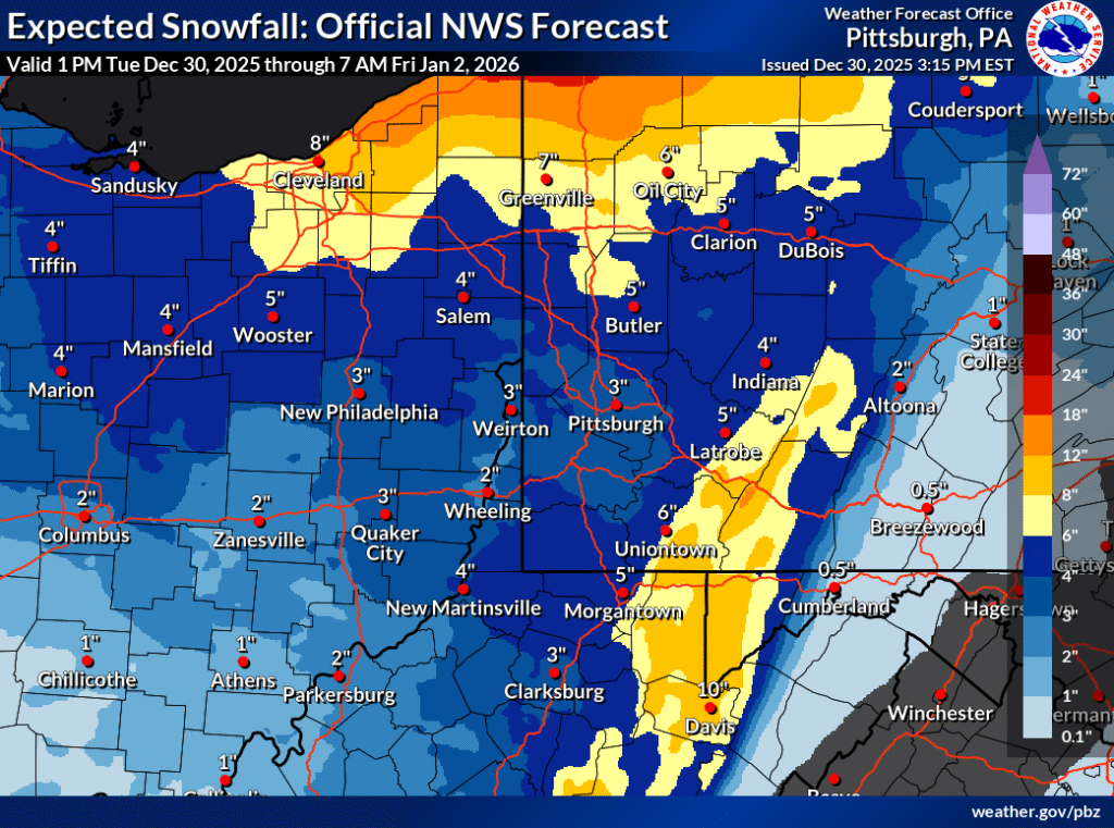
    Snowfall accumulations are expected to range from three to five inches for most locations in eastern Ohio, western Pennsylvania, and western Maryland from Tuesday afternoon through Thursday morning. Higher elevations near the spine of the Appalachians are likely to see snowfall totals in the six to eight inch range, with localized amounts approaching a foot in isolated areas. The typical snowbelt areas form northeast Ohio to southwest New York will likely see a general 12 to 18 inches. 

    The image above shows the expected snowfall accumulations across the region form Tuesday afternoon through Friday morning. Image courtesy of NWS Pittsburgh.

    Snow Squalls Likely Across Much of The Region Late Wednesday

    While snow will be ongoing for many areas by the afternoon hours on Wednesday, a line of snow squalls will likely impact the region as well. These squalls will likely spread from across the areas from northwest to southeast through the evening hours. As the squalls move through, there will be a potential for heavy snowfall rates, reduced visibility, and dangerous driving conditions. 

    The image above shows snow squall potential across the region Wednesday evening, based on the HRRR model. Image courtesy of Pivotal Weather

    While the more substantial snow accumulations are expected along and west of the Allegheny Front during the upcoming event, the advancing snow squalls are likely to bring a quick light snow accumulation to areas east of the Allegheny Front as well. As these snow squalls move across the region, travel will likely become difficult or impossible as heavy snow and gusty winds severely reduce visibility. 

    Additional resources for additional information:

  • Will There Be A White Christmas This Year?

    While Christmas is still 10 days out, the overall weather pattern across the region looks to favor milder conditions than recent weeks with fewer opportunities for snow.

    Here are some of the topics for today’s blog:

    • What Are The Teleconnections indicating For Our Upcoming Weather Pattern?
    • What Are The Forecast Ensembles Forecasting For Christmas Week?
    • Could The Forecast Trend Colder Than Currently Expected?

    Now that we have a framework for today’s blog, let’s begin our discussion. 

    What Are The Teleconnections Indicating For The Upcoming Weather Pattern?

    One of the tools that forecasters use to determine weather forecasts are the teleconnections.

    “Teleconnections are significant relationships or links between weather phenomena at widely separated locations on earth, which typically entail climate patterns that span thousands of miles.”

    These teleconnections are atmospheric and oceanic indicators that cause the jet stream to behave in specific ways. 

    Some teleconnections that forecasters typically use for long range forecasts include: 

    These teleconnections can provide insight into the nature of the large scale weather pattern in the long range. 

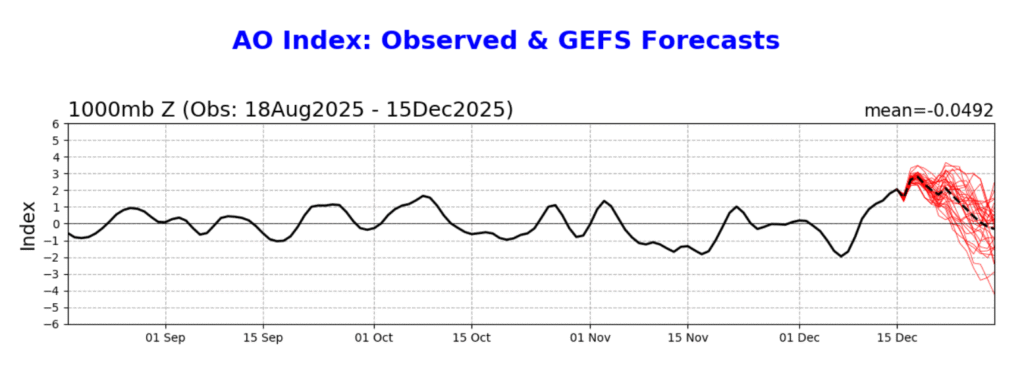
    This image shows the past observations and future forecast of the AO, based on GEFS guidance. Image courtesy of the Climate Prediction Center

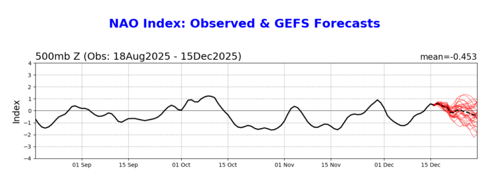
    The image above shows a depiction of the past observations and future forecast for the NAO, based on GEFS guidance. Image courtesy of Climate Prediction Center

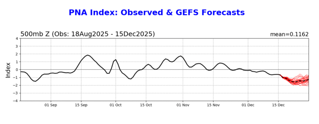
    The image above shows a depiction of the past observations and future forecast for the PNA, based on GEFS guidance. Image courtesy of the Climate Prediction Center

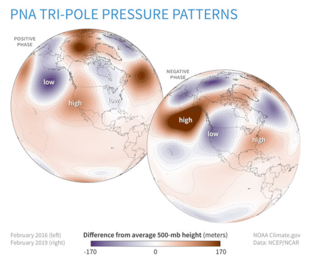
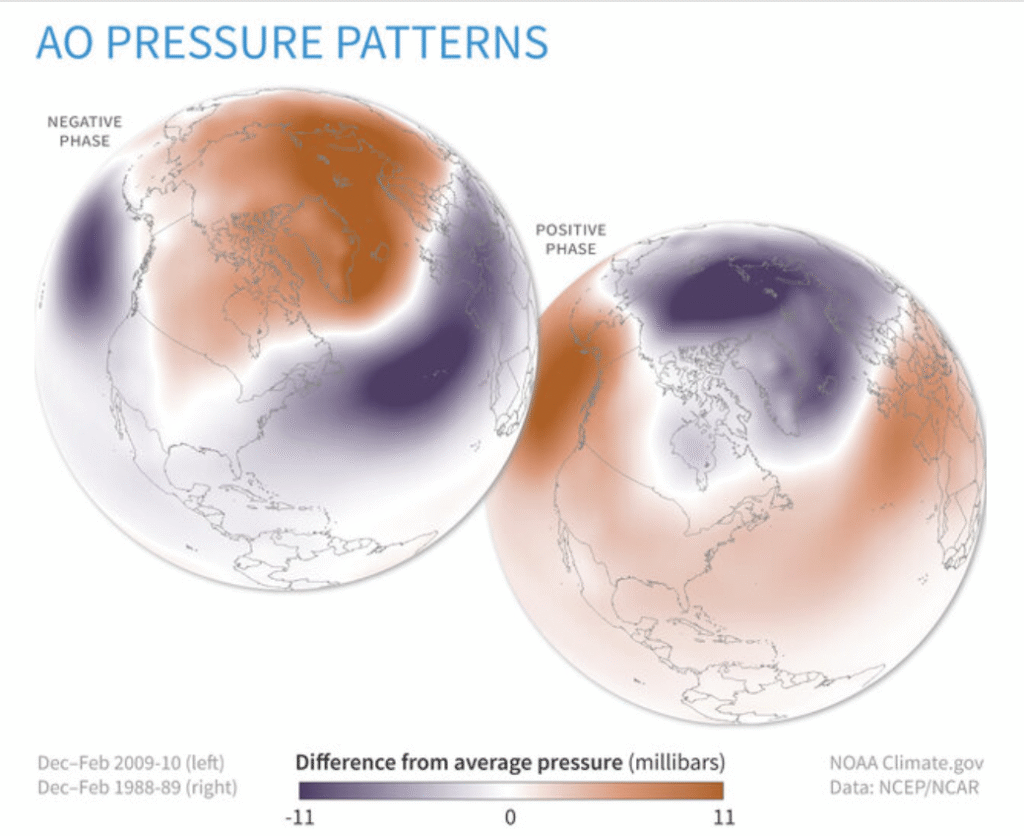
    When examining the teleconnections, the forecast seems to favor a negative PNA and a positive AO as we head toward Christmas. These teleconnections would suggest that a trough is more likely to set up along the West Coast, with limited opportunity for Arctic air to spill south out of Canada. A neutral NAO would suggest that there is not a strong signal in the North Atlantic, at least until right around Christmas. 

    The image above shows the pressure pattern correlation for the negative and positive phases of the PNA. Image courtesy of the Climate Prediction Center

    The image above shows the pressure patterns that are typically associated with the positive and negative phases of the AO. Image courtesy of the Climate Prediction Center

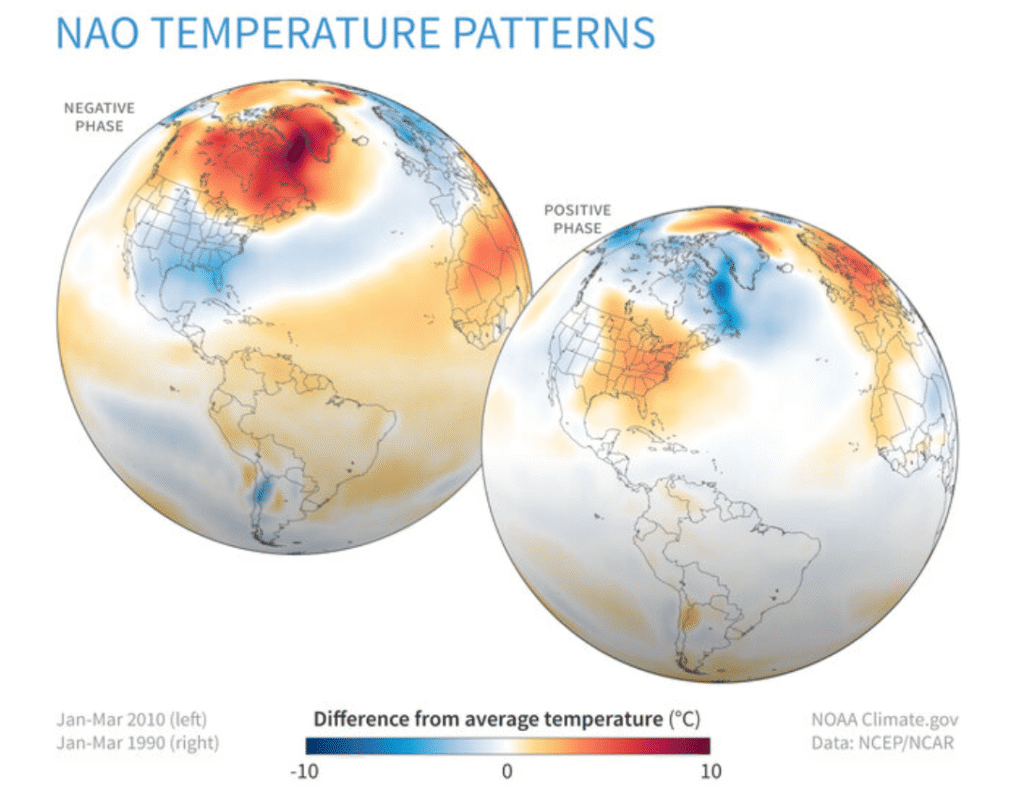
    The image above shows a depiction of the temperature patterns that are associated with the negative and positive phases of the NAO. Image courtesy of Climate Prediction Center

    If the NAO were to trend more negative faster, this could increase the odds of some colder air moving into the Northeast before Christmas. 

    What Are The Forecast Models Predicting For Christmas Week?

    While weather forecast models are typically unreliable beyond a week in advance, they can be used to give a general idea of what can be expected moving forward. Most of the ensemble forecasts are indicating that temperatures will generally be milder for much of the eastern United States as we approach Christmas, aside from possibly the Northeast. This will be aided by a lack of high latitude blocking in the North Atlantic, along with a di[p in the jet stream along the West Coast. 

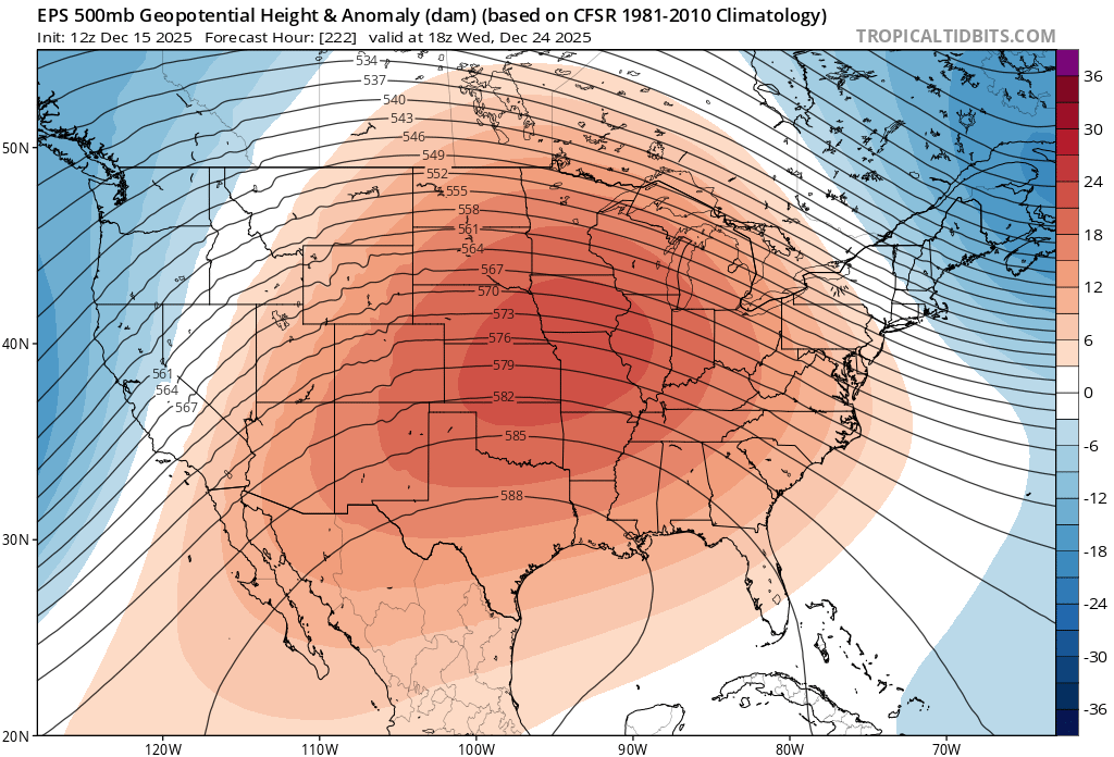
    The image above shows a depiction of the 500 mb height pattern on Christmas Eve based on ensemble guidance from the EPS model. Image courtesy of Tropical Tidbits

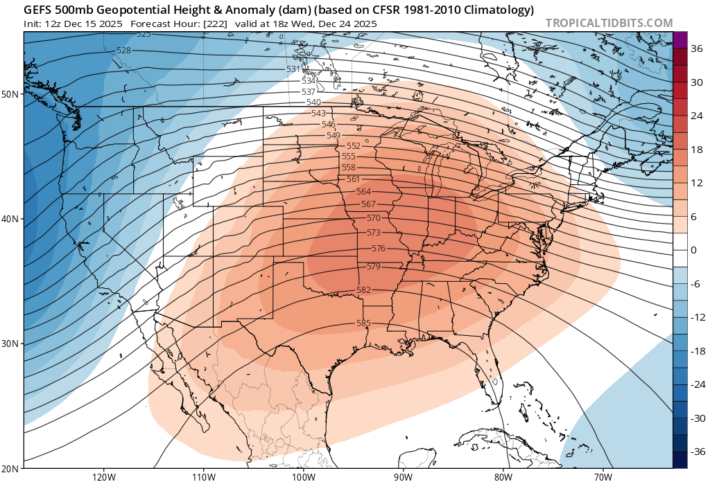
    The image above shows a depiction of the 500 mb height pattern on Christmas Eve based on ensemble guidance from the GEFS model. Image courtesy of Tropical Tidbits

    As can be seen in the images above, the GEFS and EPS ensembles indicate that a ridge is expected to set up across the central United States, with a deep trough moving into the West Coast and a weaker trough exiting the Northeast. This type of a weather pattern would likely favor a milder Christmas Eve and Christmas Day across the Central Appalachia region, reading to a low chance of seeing a white Christmas for most areas. 

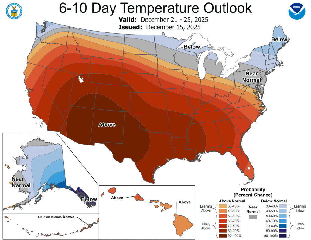
    The image above shows the temperature outlook for the United States in the days leading up to Christmas. Image courtesy of the Climate Prediction Center.

    In addition to the ensemble forecasts, there is also support for the Climate Prediction Center 6-10 Day Outlook, which indicates near to above average temperatures across the region leading up to Christmas. 

    Could The Forecast Trend Colder Than Currently Expected?

    Considering that Christmas is still almost ten days away, there will likely be some changes in the forecast moving forward. While the general thinking is that warmer weather is on the way,  there is a chance that forecast guidance could trend a bit colder. One weakness that forecast models have had recently is a tendency to overamplify the weather pattern in the long range. A more progressive pattern could potentially open the door for at least some marginally cold air, potentially leading to a slightly better chance for winter weather. With that being said, the overall consensus is that the weather pattern leading up to Christmas will not be as cold as recent weeks. 

    Additional resources for additional information:

  • Winter Weather On The Way For Midweek

    After a cold start to the week, more winter weather is on the way for the Central Appalachian region as we head through the midweek period. A clipper system will affect the region on Wednesday, bringing the opportunity for rain, accumulating snow, and strong winds to the region. 

    Here are the primary highlights for the upcoming system:

    • Accumulating snow is likely for areas near and north of interstate 80 and in the higher terrain of PA, WV, and MD on Wednesday. 
    • Low elevation areas south of Interstate 80 in PA may see little to no snow accumulation during the daylight hours on Wednesday depending on precipitation type. 
    • A light accumulating snow is likely in most areas Wednesday night into Thursday due to falling temperatures and wrap-around snow.
    • Blizzard conditions are possible in the mountains of western MD and eastern WV. 
    • Windy conditions are expected for all areas.

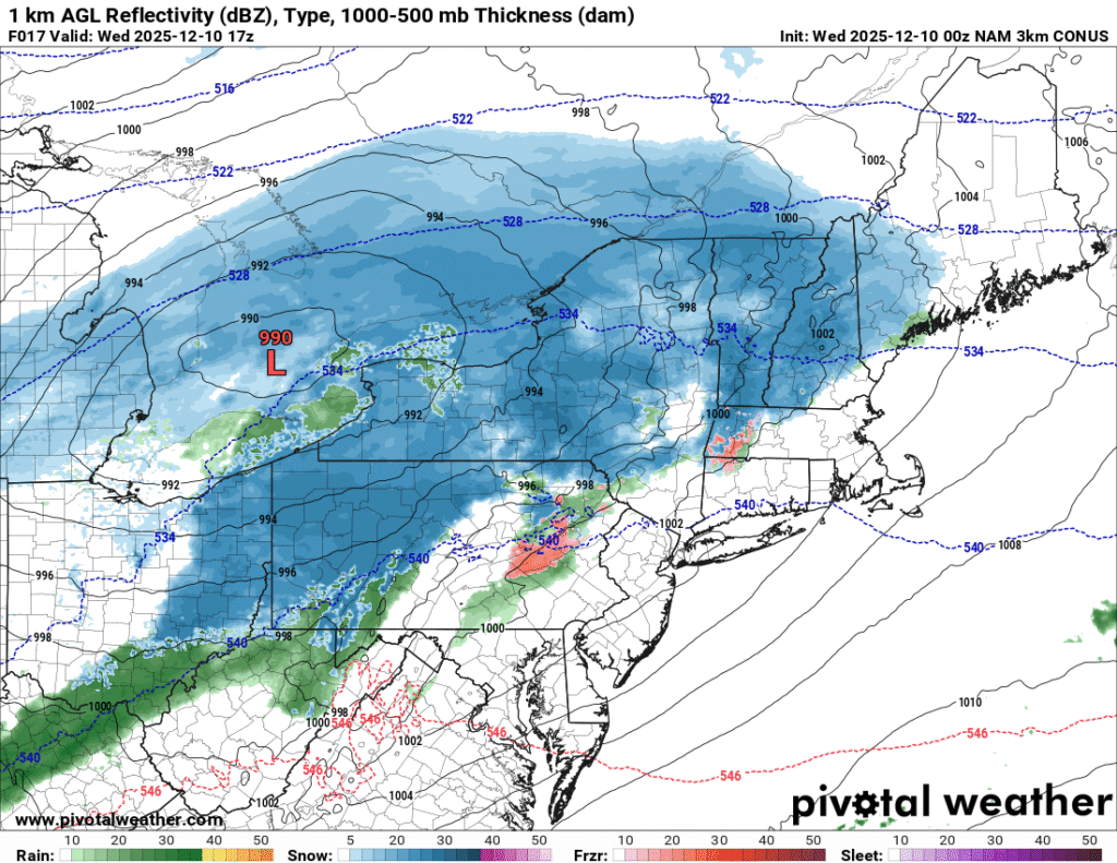
    While confidence is high in accumulating snow along and north of Interstate 80 and in the higher elevations, there is more uncertainty regarding the potential for accumulating snow in the Pittsburgh Metro area on Wednesday. Some model guidance (00z NAM 3km) would suggest that a light accumulation of snow is possible, while other guidance (00Z HRRR) would suggest that this area would receive primarily rain or a rain/snow mix, leading to little or no accumulation 

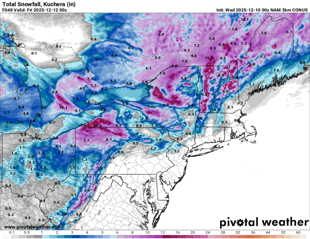
    The images above show a depiction of the expected precipitation type based on 00z NAM 3km and HRRR guidance. Image courtesy of Pivotal Weather

    As would be expected, the NAM 3km is forecasting higher snowfall totals compared to the HRRR, given that it is forecasting more of the precipitation to fall in the form of snow. In addition to the synoptic moisture associated with the system, upslope and lake effect snow will enhance the snow accumulations downwind of Lake Erie and in the higher terrain along and west of the Allegheny Front. In addition to enhanced upslope snow, strong winds will create low visibility that could create blizzard conditions in the mountains of western Maryland and West Virginia. 

    The images above show expected snowfall accumulations across the region through 00z Friday, based on the 00z HRRR and NAM 3km model guidance. Image courtesy of Pivotal Weather

    In general, 3 to 5 inches of snow can be expected across areas along and north of Interstate 80 in western Pennsylvania with 3 to 6 expected in the higher terrain of southwestern PA and northern West Virginia. 

    While there are some uncertainties in the model guidance regarding the exact amount of snow expected across the region, many areas will receive at least light accumulating snow through Thursday. As much colder air spills into the region Wednesday night, slippery travel can be expected across most areas. 

    In addition to the midweek system, there will likely be two more opportunities for snow through the weekend. 

    Additional resources for additional information: