
NWS Alert Ticker v2.3 — CAWA Coverage • Smart Pulse • Zone Descriptors
Live NWS Watches & Warnings


Author: Troy Wilson

  • Winter Storm Analysis And Update

    The first widespread winter storm of the season will impact the Central Appalachian region Monday night into Tuesday morning bringing widespread accumulating snow to much of the region. There is also a low end potential for wintry mix or freezing rain in some areas as well.

    Here are the main takeaways

    • Widespread accumulating snow is likely
    • Some chance for mixed precipitation in the pa PA and Wv ridges
    • Swath of 3-5” of snow is likely where the heaviest band of snow sets up

    Snow will begin to move into the region around midnight tonight, spreading from west to east. The snow will likely come down heavy for a time around the Tuesday morning commute. The combination of cold surface temperatures and heavy snow will cause roadways to become snow-covered and slippery. Snow will begin to taper off from west to east throughout the morning and most meaningful snow accumulation should end by noon. 

    Will There Be Any Mixed Precipitation or Rain?

    While the chance for accumulating across much of the area is high, there is a chance that enough warm air could get pulled into the system to cause some areas to see rain or a freezing rain for a period Tuesday morning. With that being said, uncertainty in this scenario is fairly high, and it is entirely possible that most areas see mainly snow. 

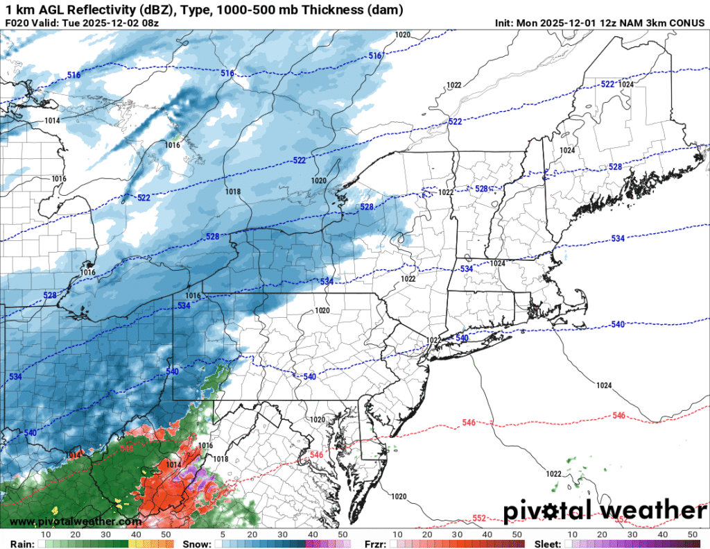
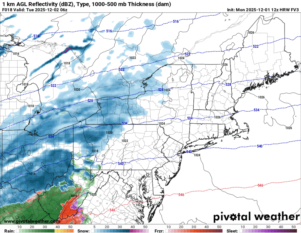
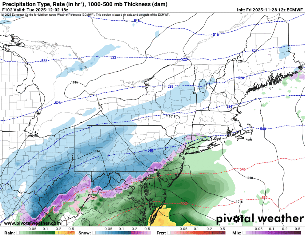
    Let’s take a moment to look at some high resolution model guidance and analyze some of the differences they present for a possible outcome. 
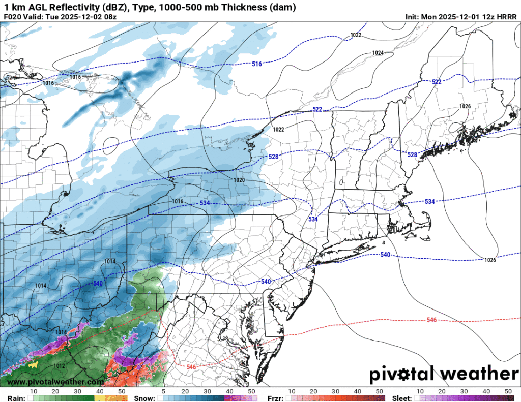
    The images above show a depiction of the precipitation type as the system approached the area Tuesday morning. Images courtesy of Pivotal Weather

    For southwestern PA, it appears that the best chance for precipitation types other than snow would be at the onset of precipitation.Thermal profiles would suggest that the temperatures will quickly fall to at or below freezing at all levels. This will likely cause a quick transition to snow for most of southwestern PA. 
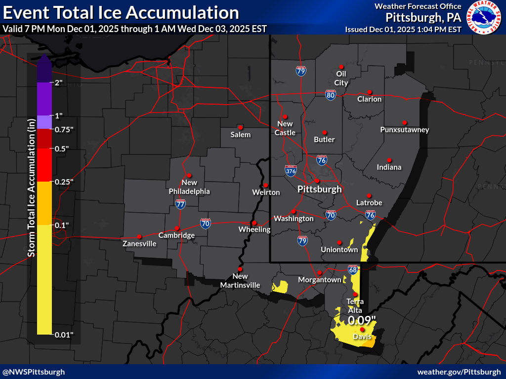
    This image highlights the potential for freezing rain in the PA and West Virginia high terrain. Image courtesy of NWS Pittsburgh.

    Further south into West Virginia, an extended period of freezing rain appears possible, which would reduce snow totals in this area. For areas in West Virginia outside of the high terrain, an extended period of rain will cut down on snow accumulations.
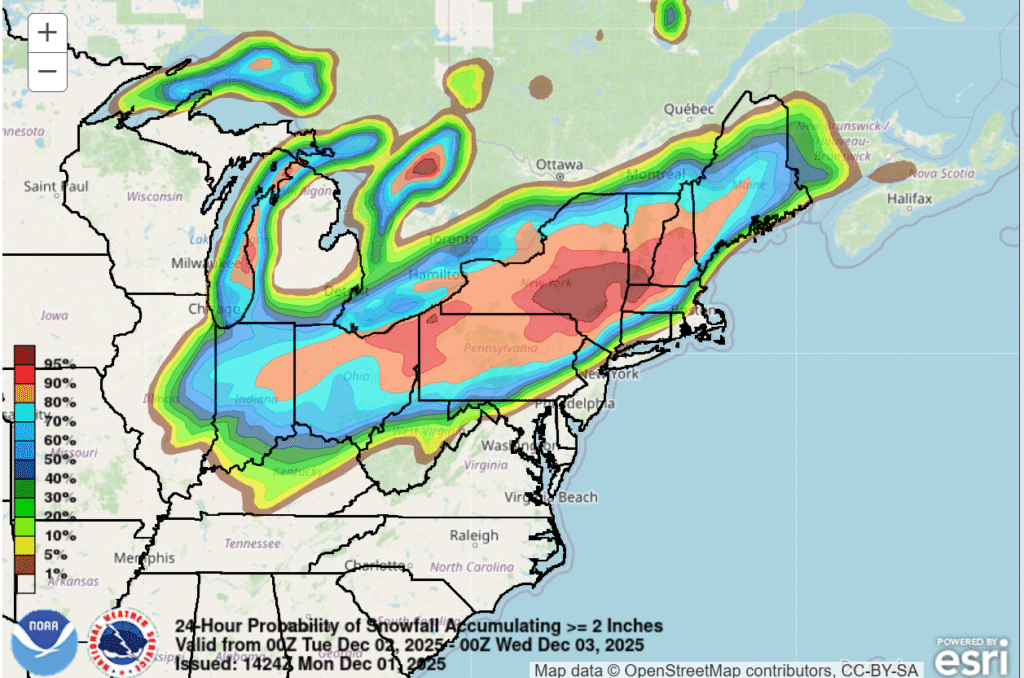
    This image shows the probability of at least two inches of snow across the region during the upcoming winter storm. Image courtesy of the Weather Prediction Center

    The main message is that the first widespread accumulating snowfall of the season is likely across the region, and the system will be disruptive to travel during the Tuesday morning commute. 

    Additional resources for additional information:
  • Is It Going To Snow Early Next Week?

    There is increasing confidence that there will be some accumulating snow across parts of the Central Appalachian region early next week. Over the past couple of days, model guidance has begun to diverge on a solution that indicates a low pressure system that will develop over the Southeastern United States and track northeast toward the Mid-Atlantic coast. 

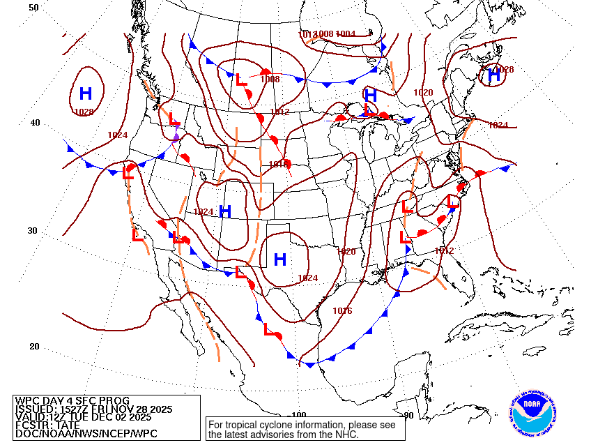
    This image shows a view of low pressure that is expected to be located over the southeastern United States early next week. Image courtesy of the Weather Prediction Center

    With an intrusion of Arctic air moving into the region Sunday night into Monday, there will be ample cold air to produce accumulating snow on the northwest side of the low pressure system. It is important to note that the system is still 3-4 days out, and the specific details regarding timing, location, and snow accumulation are uncertain at this time. 

    Here are some aspects of the forecast that are more certain:

    • A winter storm will likely affect at least parts of the region between Monday night-Tuesday night.
    • At least some snow accumulation is likely.
    • The chance of travel impacts is relatively high. 

    Here are some aspects of the forecast that are more uncertain at this time:

    • The exact strength and track of the storm is still a bit uncertain
    • The amount of moisture that will overlap with the cold air. 
    • Snowfall totals in any specific location.
    • The location of the rain/snow line.
    • Ice accretion from freezing rain.

    What Is The Most Likely Outcome Based On Current Forecast Model Projections?

    While there are some differences in the models forecast models, the overall consensus indicates that there will be a favorable storm track for accumulating snow for portions of the Ohio Valley, Central Appalachians, Mid-Atlantic, and Northeast. 

    With that being said, let’s take a moment to look at some of the models to see where they agree and disagree regarding next week’s system.

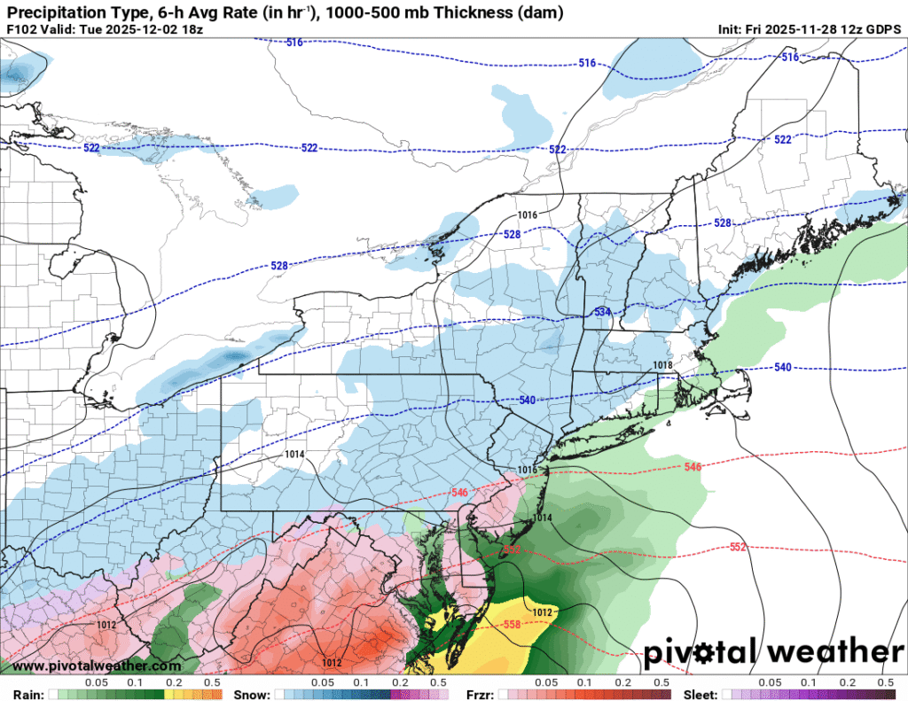
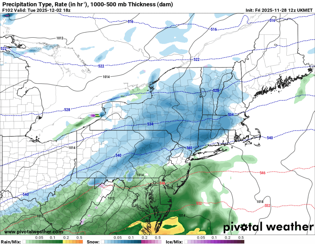
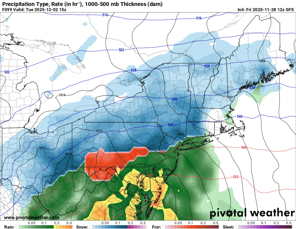
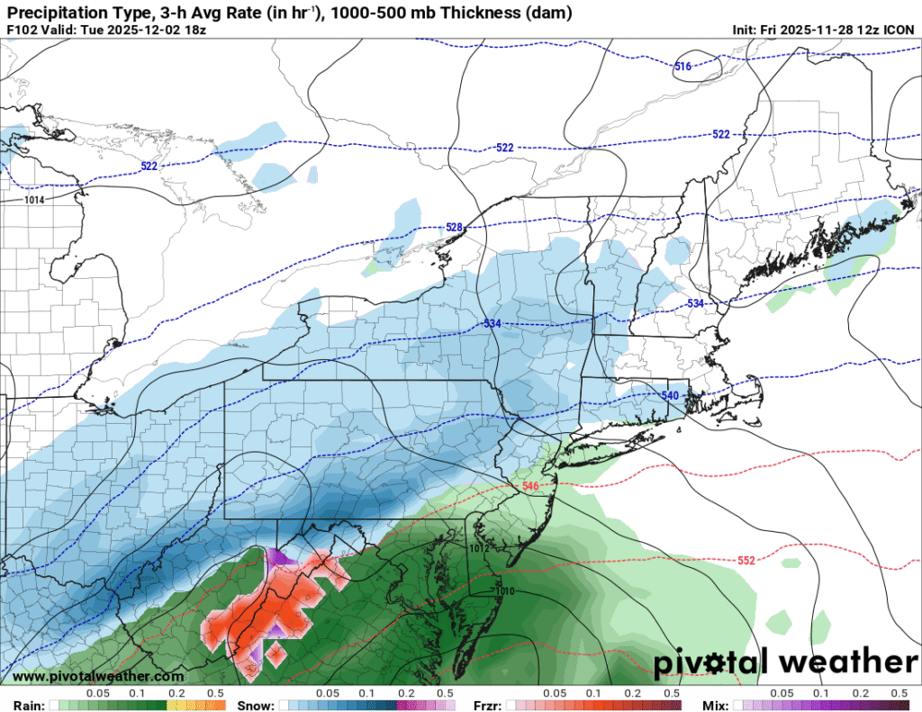
    These images show a depiction of precipitation type and intensity for Tuesday based on 12z guidance from the GFS, ICON, Canadian, UKMET, and European forecast models. Image courtesy of Pivotal Weather

    As you can see, there are still uncertainties regarding the timing, intensity, and track of the low pressure system. There are also uncertainties regarding the location of the rain/snow line, and any mixed frozen precipitation risks that may occur near this line. The big picture is that impactful winter weather is likely early next week, and differences in the models will work themselves out over the next few days. 

    Additional resources for additional information:
  • Thanksgiving Week Weather Forecast Update

    While it has been a mild start to Thanksgiving week, that will certainly change as we approach Thanksgiving Day. Many areas across the Central Appalachia region are currently experiencing wet and relatively mild conditions as a storm system slides through the area. 

    Here is a breakdown of what to expect through the remainder of the week

    • Scattered showers and increasingly windy conditions as a strong cold front approaches from the west on Wednesday. 
    • Scattered snow showers, well below average temperatures, and windy conditions for Thanksgiving Day.
    • Significant lake effect snow accumulation from northeast Ohio to western New York from Wednesday night through Friday.
    • A storm system will bring the likelihood of moderating temperatures and the risk for rain and snow over the weekend.

    What is the Forecast for Pre-Thanksgiving Travel?

    As previously mentioned, Wednesday will feature the approach of a strong cold font that will cause a transition to much colder weather at midweek. 

    Here are a few things to keep in mind:

    • Showers will become more numerous from west to east as the day progresses. 
    • Much colder air will arrive Wednesday night, with the potential for some snow showers along and west of the Allegheny Front.
    • Lake effect may begin to impact parts of the primarily snowbelts from northeast Ohio to western New York.

    What Is The Weather Forecast For Thanksgiving Day?

    Some important things that you should be aware of regarding the Thanksgiving forecast include: 

    • Well below average temperatures across the entire region.
    • Gusty winds will accompany the winter-like chill.
    • Lake effect snow will affect the primary snowbelt areas.
    • Scattered snow showers are possible along and west of the Allegheny Front.

    Thanksgiving Day will likely feel more like the middle of winter than late fall across the Central Appalachia region. 

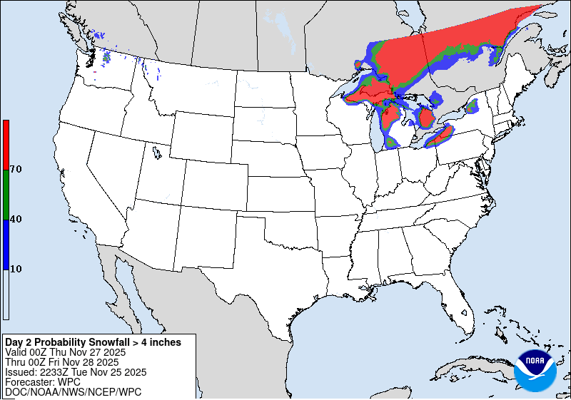
    This image highlights the increased likelihood of impactful lake snow on Thanksgiving Day downwind of Lake Erie. Image courtesy of Weather Prediction Center

    While it will be cold for all areas of the region, those living downwind of Lake Ontario and Lake Erie will experience impactful lake effect snow at times throughout the day. The Weather Prediction is indicating that there is at least a 70 percent chance of 4 inches of snow or more for these areas on Thanksgiving Day. 

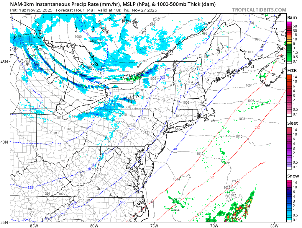
    This image shows a depiction of expected lake effect snow on Thanksgiving Day. Image courtesy of Tropical Tidbits

    It is important to note that this is just one model depiction and the location of lake effect snow bands can vary based on the direction of the wind. The main message is that those traveling toward the primary snowbelts on Thanksgiving Day should be prepared for rapidly changing weather conditions. 

    What Will The Weather Be Like For Black Friday And Post-Holiday Travel?

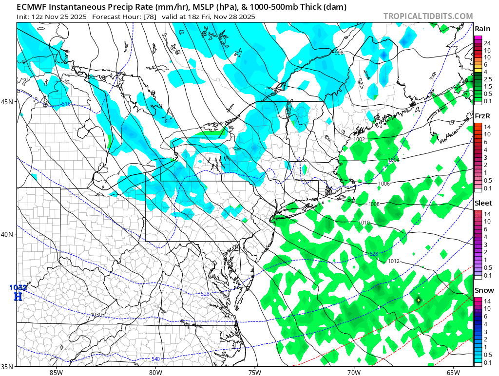
    For much of the region, Black Friday will feature a continuation of the cold and windy conditions. Lake effect snow will likely be ongoing in the typical lake effect regions previously mentioned. 

    This image shows a visual of the continued lake effect activity downwind of the lakes on Black Friday. Image courtesy of Tropical Tidbits

    As we head into the day on Saturday, the weather will likely start off cold and dry across the region.

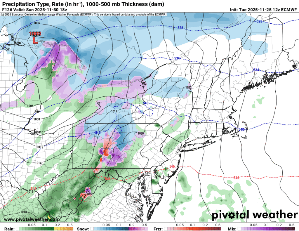
    This image indicates the potential for mixed precipitation on Sunday. Image courtesy of Pivotal Weather

    As we close out the weekend on Sunday, a storm system over the Plains will likely move toward the region providing the opportunity for precipitation chances. The precipitation type will depend on how much cold is still in place across the region. 

    Additional resources for additional information:
  • Thanksgiving Week Weather Forecast Update

    While there is still some uncertainty regarding the weather forecast for the Central Appalachian region, there are some general ideas that seem to be emerging in the model guidance.

    Here is a breakdown of the Thanksgiving week forecast:

    • A seasonably cool, but generally quiet start to the week on Monday
    • A milder, but more unsettled period for Tuesday into Wednesday
    • A colder weather pattern will take shap around Thanksgiving Day
    • A low end winter weather impact is possible around late week. 
    • A moderating trend by the end of the weekend

    What Is The Pre-Thanksgiving Weather Forecast?

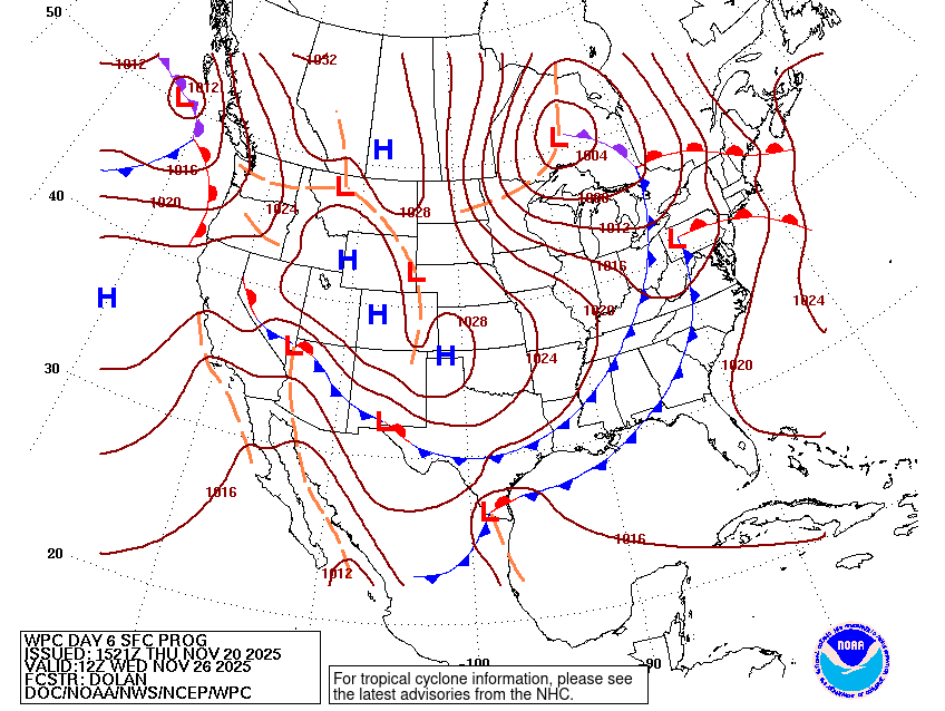
    The beginning of Thanksgiving week is likely to favor seasonably cool, but dry weather conditions over the Central Appalachians. As we head into the day on Tuesday, a weather system will likely move northeast from the Southern Plains toward the Great Lakes. This system will likely bring the chance for rain to the forecast as we head into the day on Tuesday. Rain chances will likely continue until the passage of a cold front around or just prior to Thanksgiving Day. 

    The model image above highlights the approach of a strong cold front at midweek. Image courtesy of the Weather Prediction Center

    What Should You Expect For Your Thanksgiving Day Forecast?

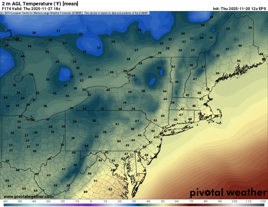
    As we head out to our family gatherings to eat turkey and watch football, there is some uncertainty in the forecast across the Central Appalachian region. Most of the uncertainty is regarding the timing of the midweek cold font. An earlier passage would likely mean a colder Thanksgiving Day, with the potential for some snow showers or flurries. If the front is more delayed, Thanksgiving Day could shape up to be an unsettled day with seasonal temperatures. 

    This image shows forecasted highs for the Central Appalachia region on Thanksgiving Day based on European ensemble guidance. Image courtesy of Pivotal Weather

    Is It Going To Snow After Thanksgiving?

    While this time period is over a week away,  there is no indication that there will be widespread significant snowfall across the region. While there is the potential for lake effect snow, the details of any potential impacts are highly uncertain at this range. 

    Depending on how quickly the cold air retreats, there may be some moderation in temperatures during the weekend. 

    The forecast is still about a week out, and there will need to be modifications to the forecast as we get closer to the Thanksgiving holiday.

    Here is a quick recap of the Thanksgiving week weather forecast:

    • The week will likely start on a seasonably cool, but dry note.
    • There will likely be a couple days of mild, but unsettled weather as we approach Thanksgiving Day
    • Thanksgiving Day will likely turn colder
    • Any meaningful snow accumulation around late week will likely be connected to lake effect. 
    • A moderating trend is possible late in the weekend

    Be sure to check back for updates to the Thanksgiving weatehr forecast as the computer models begin to diverge on a solution.

  • What Is The Weather Forecast For Thanksgiving Week?

    While there is still some uncertainty regarding the weather forecast for the Central Appalachian region, there are some general ideas that seem to be emerging in the model guidance.

    Here is a breakdown of what we are expecting at this point:

    • A seasonably cool, but generally quiet start to the week
    • A milder, but more unsettled period leading up to Thanksgiving
    • The potential for a much colder and wintry pattern to take shape in the days following Thanksgiving

    What Is The Pre-Thanksgiving Weather Forecast?

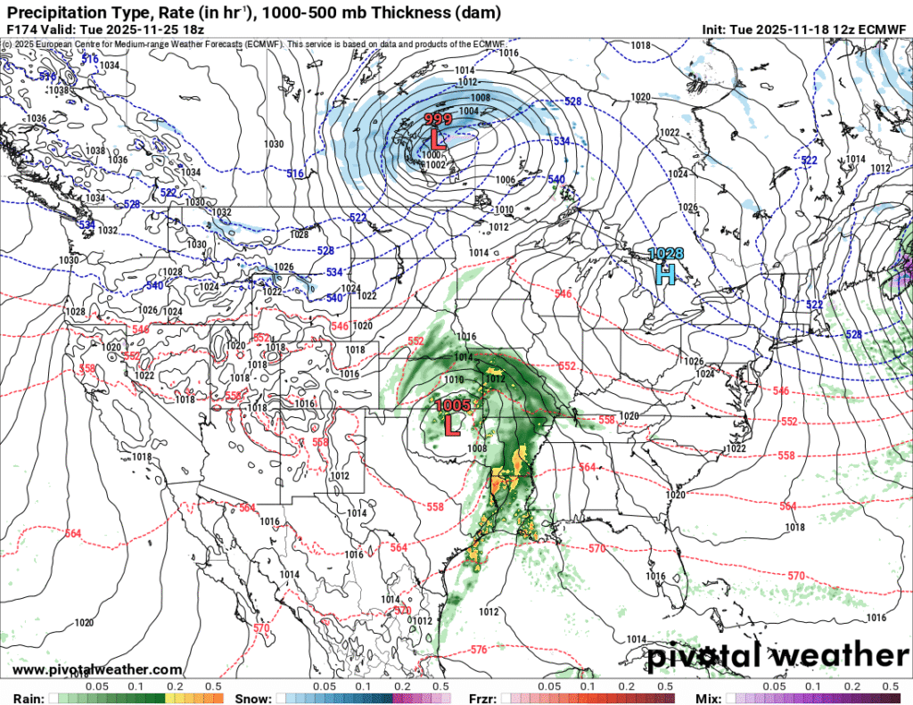
    The beginning of Thanksgiving week is likely to favor seasonably cool, but dry weather conditions over the Central Appalachians. As we head into the day on Tuesday, a weather system will likely move northeast from the Southern Plains toward the Great Lakes.This system will likely bring the chance for rain to the forecast as we head toward mid-week.

    The model image above shows the approach of a weather system at mid-week that will follow a relatively calm start to the week. Image courtesy of Pivotal Weather.

    What Should You Expect For Your Thanksgiving Day Forecast?

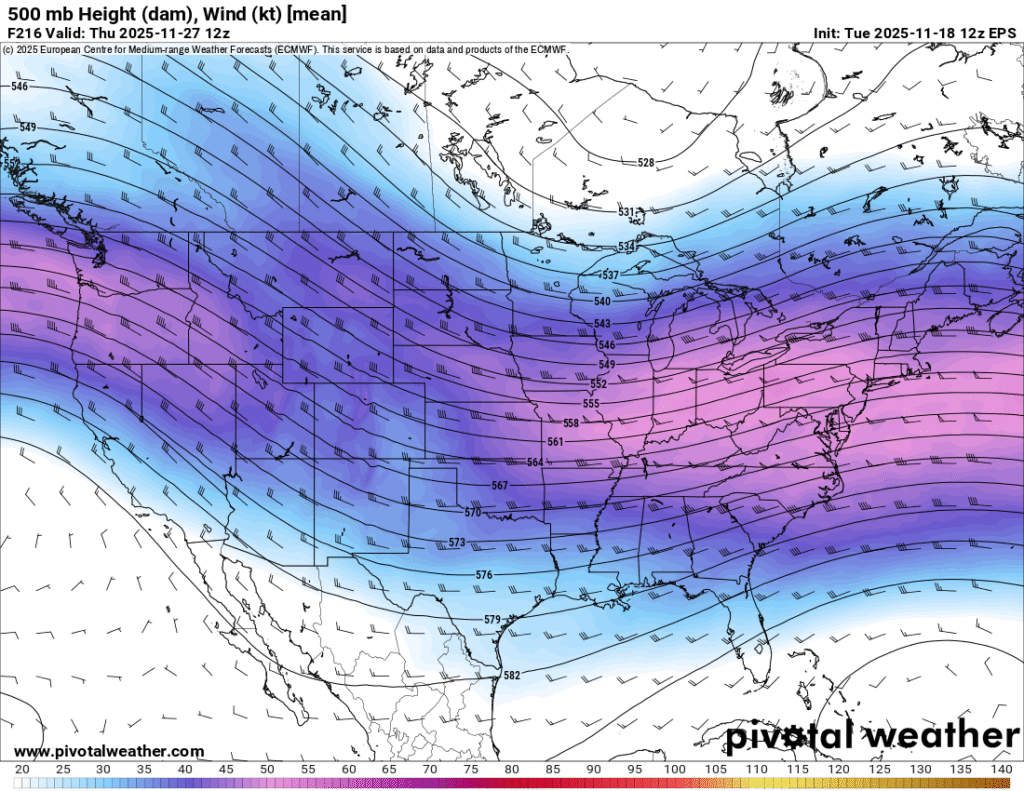
    As we head out to our family gatherings to eat turkey and watch football, the pattern across the Central Appalachian region will likely turn stormy as an amplified polar jet begins to dive toward the central and Eastern United States. Some uncertainty exists regarding the timing of a cold front that will usher in much colder air. As it stands right now, Thanksgiving day may be a transitional weather day with unsettled weather conditions. At this point, it appears the system will mostly bring precipitation in the form of rain for most areas, but this is subject to change. In addition, there could also be a wind component as well.

    This image shows a dip in the jet stream that is projected to move through the Central U.S. around Thanksgiving. Image courtesy of Pivotal Weather.

    Is It Going To Snow After Thanksgiving?

    While this time period is over a week away, there are indications that the weather pattern will turn much colder. There is also the potential for some winter weather as well.

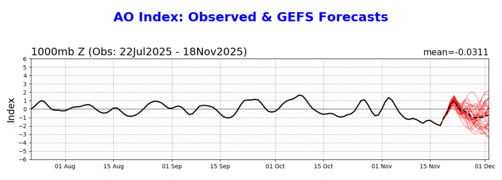
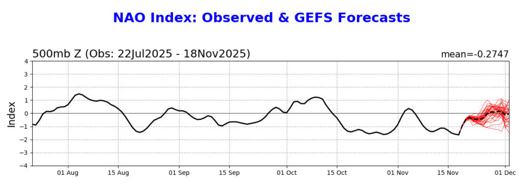
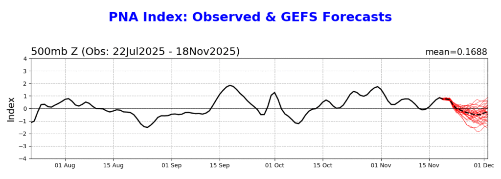
    One of the primary ways that forecasters get insights for long range forecasting involves Teleconnections. Some of the more common teleconnections that forecasters use to forecast long range weather patterns include:

    • North Atlantic Oscillation (NAO)
    • Arctic Oscillation (AO)
    • Pacific-North American Index (PNA)

    The images above show the history and forecast of the AO, NAO, and PNA. Images courtesy of the Climate Prediction Center.

    A negative phase of the NAO tends to lead to colder and unsettled conditions in the Eastern U.S. While a negative AO does not directly correlate to a colder pattern in the Eastern U.S., it does tend to offer more opportunities for cold air to sink southward. In contrast to the NAO, the negative phase of the PNA tends to favor colder conditions in the western United States.

    Bottom Line

    The forecast is still about a week out, and there will need to be modifications to the forecast as we get closer to the Thanksgiving holiday.

    Here is a quick recap of the Thanksgiving week weather forecast:

    • The week will likely start on a seasonably cool, but dry note.
    • There will likely be a couple days of mild, but unsettled weather as we approach Thanksgiving Day
    • Black Friday and the weekend following Thanksgiving will likely turn colder with the potential for some winter weather impacts.

    Be sure to check back for updated information as the forecast models begin to diverge on a forecast solution.