
While Christmas is still 10 days out, the overall weather pattern across the region looks to favor milder conditions than recent weeks with fewer opportunities for snow.
Here are some of the topics for today’s blog:
- What Are The Teleconnections indicating For Our Upcoming Weather Pattern?
- What Are The Forecast Ensembles Forecasting For Christmas Week?
- Could The Forecast Trend Colder Than Currently Expected?
Now that we have a framework for today’s blog, let’s begin our discussion.
What Are The Teleconnections Indicating For The Upcoming Weather Pattern?
One of the tools that forecasters use to determine weather forecasts are the teleconnections.
“Teleconnections are significant relationships or links between weather phenomena at widely separated locations on earth, which typically entail climate patterns that span thousands of miles.”
These teleconnections are atmospheric and oceanic indicators that cause the jet stream to behave in specific ways.
Some teleconnections that forecasters typically use for long range forecasts include:
These teleconnections can provide insight into the nature of the large scale weather pattern in the long range.
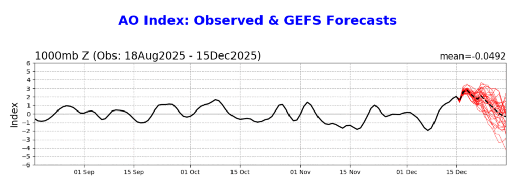
This image shows the past observations and future forecast of the AO, based on GEFS guidance. Image courtesy of the Climate Prediction Center.
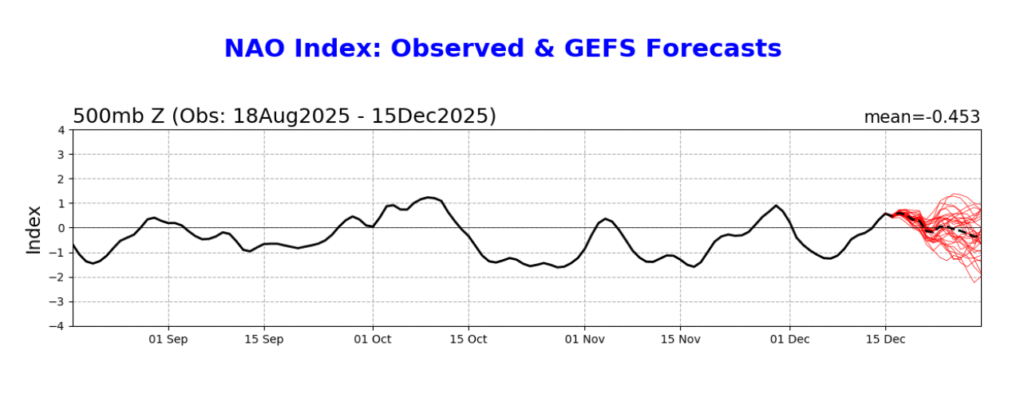
The image above shows a depiction of the past observations and future forecast for the NAO, based on GEFS guidance. Image courtesy of Climate Prediction Center.
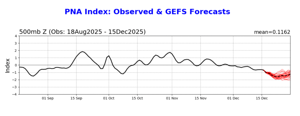
The image above shows a depiction of the past observations and future forecast for the PNA, based on GEFS guidance. Image courtesy of the Climate Prediction Center.
When examining the teleconnections, the forecast seems to favor a negative PNA and a positive AO as we head toward Christmas. These teleconnections would suggest that a trough is more likely to set up along the West Coast, with limited opportunity for Arctic air to spill south out of Canada. A neutral NAO would suggest that there is not a strong signal in the North Atlantic, at least until right around Christmas.
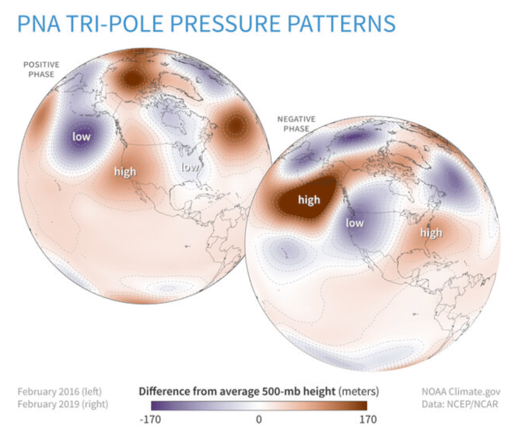
The image above shows the pressure pattern correlation for the negative and positive phases of the PNA. Image courtesy of the Climate Prediction Center.
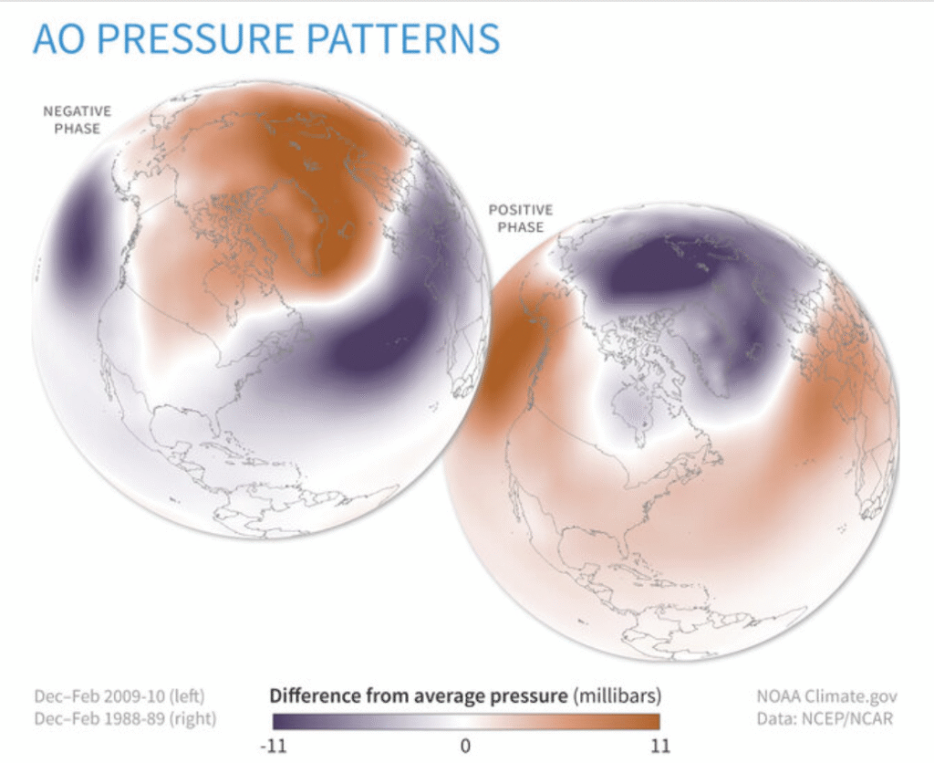
The image above shows the pressure patterns that are typically associated with the positive and negative phases of the AO. Image courtesy of the Climate Prediction Center.
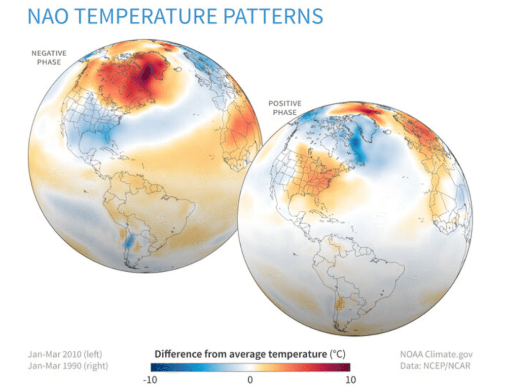
The image above shows a depiction of the temperature patterns that are associated with the negative and positive phases of the NAO. Image courtesy of Climate Prediction Center.
If the NAO were to trend more negative faster, this could increase the odds of some colder air moving into the Northeast before Christmas.
What Are The Forecast Models Predicting For Christmas Week?
While weather forecast models are typically unreliable beyond a week in advance, they can be used to give a general idea of what can be expected moving forward. Most of the ensemble forecasts are indicating that temperatures will generally be milder for much of the eastern United States as we approach Christmas, aside from possibly the Northeast. This will be aided by a lack of high latitude blocking in the North Atlantic, along with a di[p in the jet stream along the West Coast.
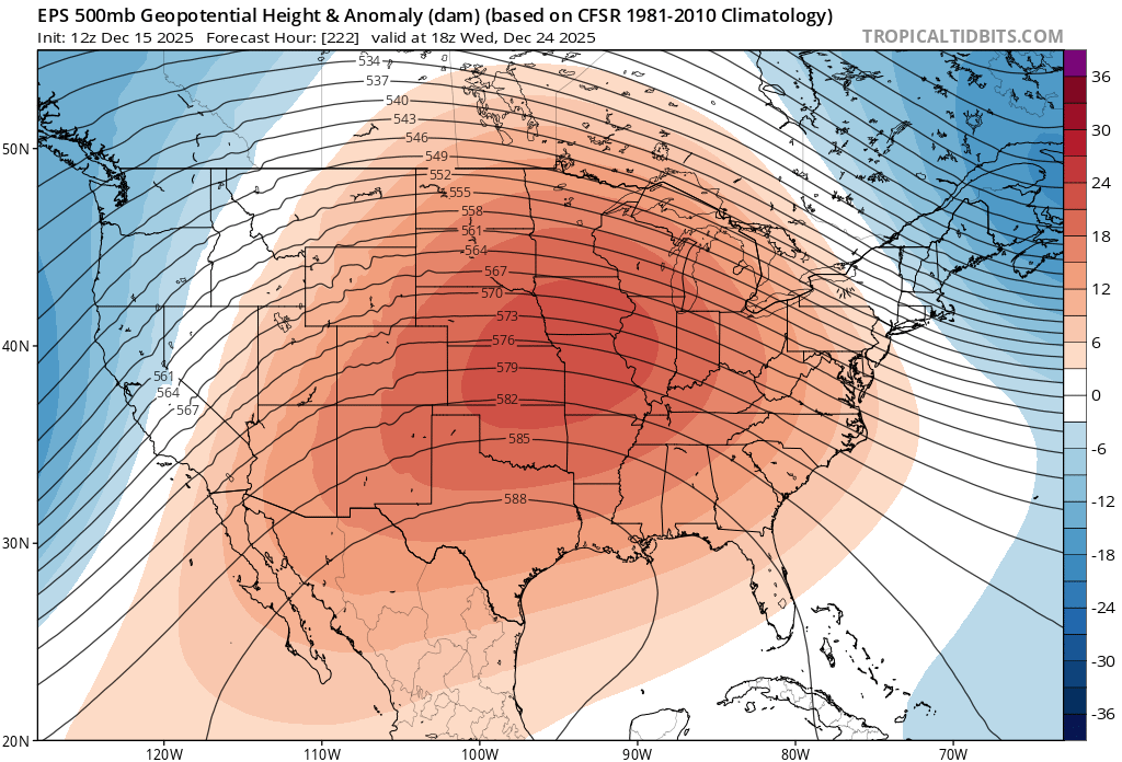
The image above shows a depiction of the 500 mb height pattern on Christmas Eve based on ensemble guidance from the EPS model. Image courtesy of Tropical Tidbits.
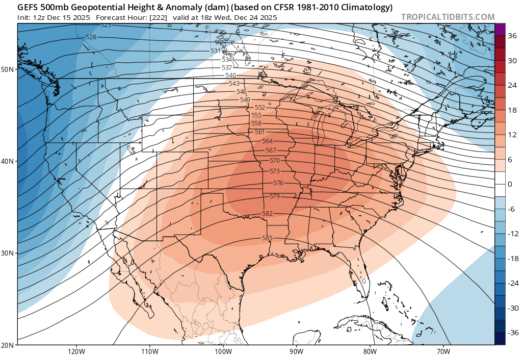
The image above shows a depiction of the 500 mb height pattern on Christmas Eve based on ensemble guidance from the GEFS model. Image courtesy of Tropical Tidbits.
As can be seen in the images above, the GEFS and EPS ensembles indicate that a ridge is expected to set up across the central United States, with a deep trough moving into the West Coast and a weaker trough exiting the Northeast. This type of a weather pattern would likely favor a milder Christmas Eve and Christmas Day across the Central Appalachia region, reading to a low chance of seeing a white Christmas for most areas.
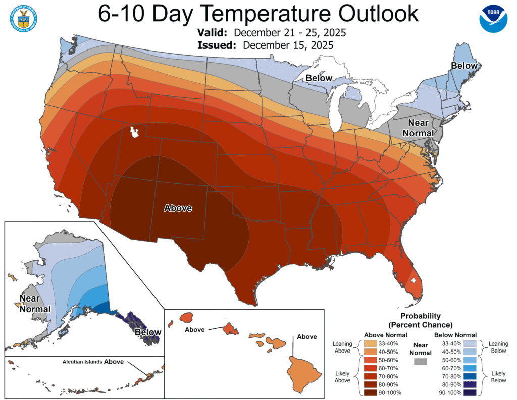
The image above shows the temperature outlook for the United States in the days leading up to Christmas. Image courtesy of the Climate Prediction Center.
In addition to the ensemble forecasts, there is also support for the Climate Prediction Center 6-10 Day Outlook, which indicates near to above average temperatures across the region leading up to Christmas.
Could The Forecast Trend Colder Than Currently Expected?
Considering that Christmas is still almost ten days away, there will likely be some changes in the forecast moving forward. While the general thinking is that warmer weather is on the way, there is a chance that forecast guidance could trend a bit colder. One weakness that forecast models have had recently is a tendency to overamplify the weather pattern in the long range. A more progressive pattern could potentially open the door for at least some marginally cold air, potentially leading to a slightly better chance for winter weather. With that being said, the overall consensus is that the weather pattern leading up to Christmas will not be as cold as recent weeks.
Additional resources for additional information:
Leave a Reply