


By now, many of you have probably heard many conversations in the news or on social media regarding El Nino. The National Oceanic and Atmospheric Administration (NOAA) is expecting the development of El Nino this summer, and it will likely strengthen as we head into the fall and winter. Social media is saturated with people trying to spread hype and fear over weather events like El Nino. While El Nino certainly impacts our weather in certain ways, there is no reason to become anxious about the weather over the next several months. In this blog, we will bring some clarity to the subject of El Nino, and discuss some of the ways that it could impact our weather in the coming months. We will also briefly discuss the impacts that it could have on our weather in the upcoming winter as well.
Some topics we will discuss in this blog include:
- What is El Nino?
- How Does El Nino Affect The Jet Stream?
- What Atmospheric And Oceanic Conditions Allow For The Formation of Tropical Systems?
- How Does El Nino Impact The Hurricane Season?
- How Does El Nino Affect Winter Weather?
What is El Nino?
Before we discuss El Nino, let’s take a moment to talk about the El Nino Southern Oscillation Index (ENSO). ENSO is nothing more than a measurement of the sea surface temperatures (SST) in the equatorial eastern Pacific. The ENSO has two primary phases that oscillate depending on the strength of the trade winds. The cold phase of ENSO is classified as a La Nina.
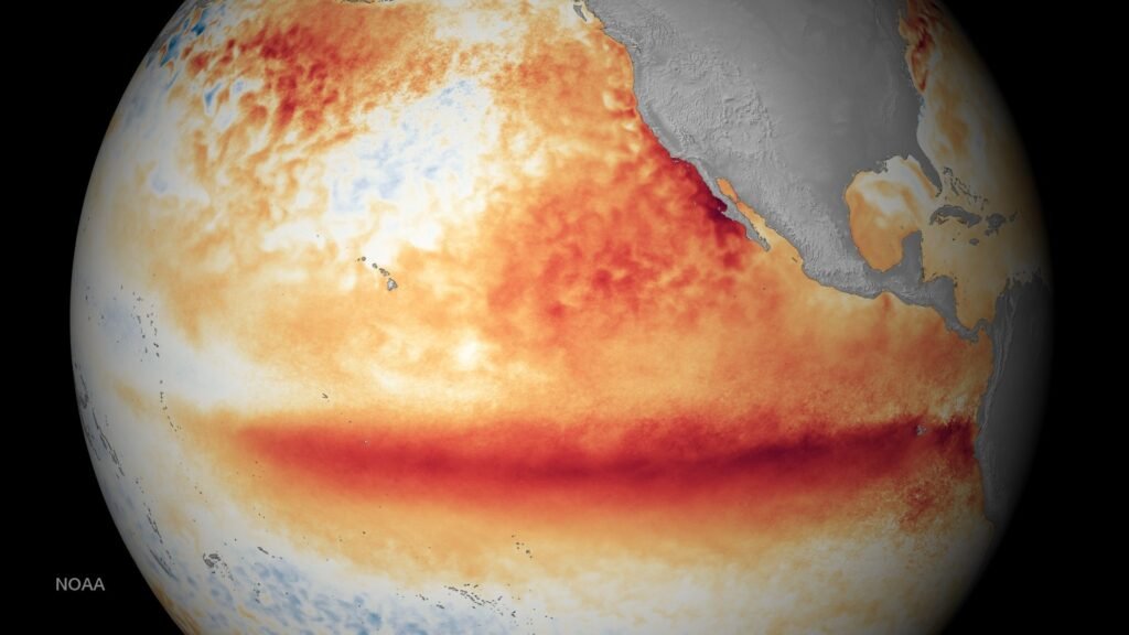
This image shows a depiction of the warm eastern Pacific SST as a result of the 2015 El Nino. Image courtesy of NOAA.
This phase is observed when SST drop to 0.5 degrees below average or lower for three consecutive months in the Nino 3.4 region. On the other hand, the warm phase of the ENSO is classified as El Nino. El Nino occurs when SST in the Nino 3.4 region rise to 0.5 degrees or higher for three consecutive months.
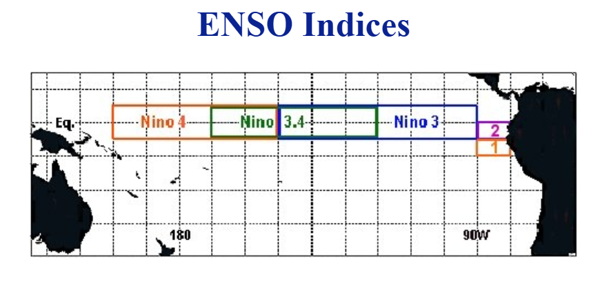
Image above shows a depiction of various ENSO regions in the eastern Pacific Ocean. NOAA defines the Enso phase based on the SSST in the Nino 3.4 region. Image courtesy of National Weather Service.
How Does El Nino Affect The Jet Stream?
There are two primary jet streams that affect the weather around the globe. The first is the Polar jet stream. In the Northern Hemisphere, this is the northern branch of the jet stream that helps to transport cold Arctic air southward toward the mid-latitudes. In contrast, the Subtropical Jet helps to transport moisture across the mid-latitudes. When the sun heats the surface of the tropics, it causes air parcels to rise and move north or south. Once the air cools, it begins to sink back down. These circulations of air are known as the Hadley cells. The subtropical jet forms high up in the atmosphere near the northern edge of the Hadley Cell in the Northern Hemisphere (around 30 degrees N). This moisture is then transported eastward. That is why the southern branch of the jet stream is more active during El Nino. The warm water near the equatorial Pacific provides the moisture that eventually gets transported by the Subtropical Jet.
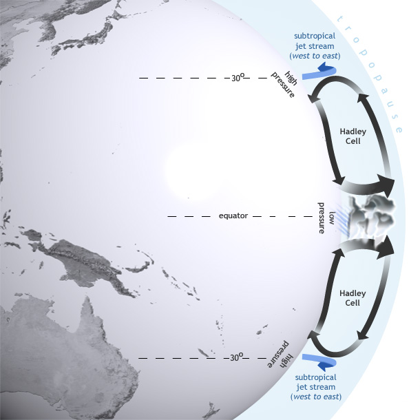
This image shows how the Hadley Cells and Subtropical Jet combine to transport moisture northward toward the mid-latitudes. Image courtesy of National Oceanic And Atmospheric Administration.
If the northern branch of the jet stream becomes amplified, the two branches can phase, causing large mid-latitude cyclones. During El Nino, the Subtropical Jet strengthens as a result of the warm water in the equatorial Pacific Ocean. This warm water helps to initiate convection that is transported eastward with the Subtropical Jet Stream. In contrast, stronger flow in the Polar Jet tends to remain further to the north. While the effects of El Nino may be felt during the summer months, its impacts are much greater during the winter.
What Atmospheric And Oceanic Conditions Allow For The Formation of Tropical Systems?
As we have already discussed, El Nino often results in an active Subtropical Jet. Because tropical systems often form in the subtropical regions of the Atlantic and Pacific Ocean, the presence of El Nino can directly impact tropical weather. As we enter the start of hurricane season, there are a couple of important notes regarding El Nino’s impacts.
Before we continue our discussion, let’s talk about how tropical systems form, and the type of environment that is necessary for them to strengthen into hurricanes. Tropical systems generally need SST of at least 80 degrees Fahrenheit, moist mid levels of the atmosphere, and unstable air in order for development to occur. In the eastern Atlantic Ocean, tropical systems often form as a result of waves of low pressure that are transported westward by the trade winds. This region is often known as the InterTropical Convergence Zone. In this region, warm water can lead to robust convection that results in tropical cyclone development. Similar to the Atlantic, tropical development in the eastern Pacific is often due to moisture transported by trade winds. Another factor that can cause tropical development is the Central American gyre. This area of low pressure can help form low pressure systems in the Caribbean Sea. These systems often move northward toward the United States or westward through Mexico and the eastern Pacific
How Does El Nino Impact The Hurricane Season?
Now that we have established some of the ways that tropical systems develop, let’s discuss how El Nino can impact these systems. Due to the active Subtropical Jet pushing eastward toward the Atlantic Ocean, the hurricane season in this region is often hindered by increased wind shear in the upper levels of the atmosphere. The development of tropical systems requires high pressure and divergent winds in the upper levels of the atmosphere. This helps to enhance vertical growth and air ventilation. While El Nino often leads to a less active tropical season in the Atlantic, it is important to remember that tropical systems can still occur and deliver substantial impacts.
Unlike the Atlantic Basin, the eastern Pacific often sees a more active hurricane season. Wind shear created by the Subtropical Jet can negatively influence tropical activity in the Atlantic; however, the affects of this wind shear are typically not as prevalent in the eastern Pacific. This is because high pressure is normally more prevalent further west in the equatorial Pacific during El Nino. As a result, upper level winds tend to be more conducive for tropical development in this region.
How Does El Nino Affect Winter Weather?
An active Subtropical Jet has major implications for the winter weather pattern across North America. During an El Nino, the Polar branch of the jet stream tends to remain further north into Canada, which helps to bottle up Arctic air to the north of the continental U.S. This often leads to warmer than average temperatures and below average snowfall across the northern United States. Across the southern United States, El Nino typically leads to a cooler and wetter than average winter due to increased moisture in this area.
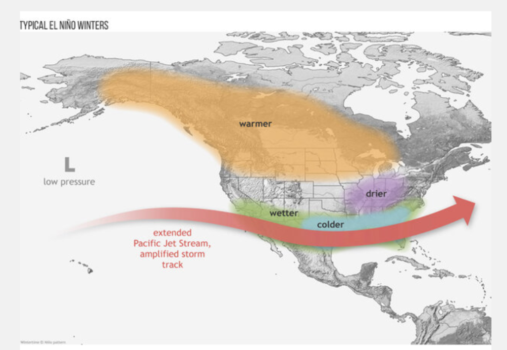
The image above shows the typical winter jet stream pattern that is represented during El Nino. Image courtesy of Cclimate.gov.
It is also important to note that the strength of El Nino is important. If El Nino becomes strong, it is more likely to become the main component that drives the jet stream pattern. If El Nino remains weak; however, other teleconnections can override El Nino and provide a different outcome.
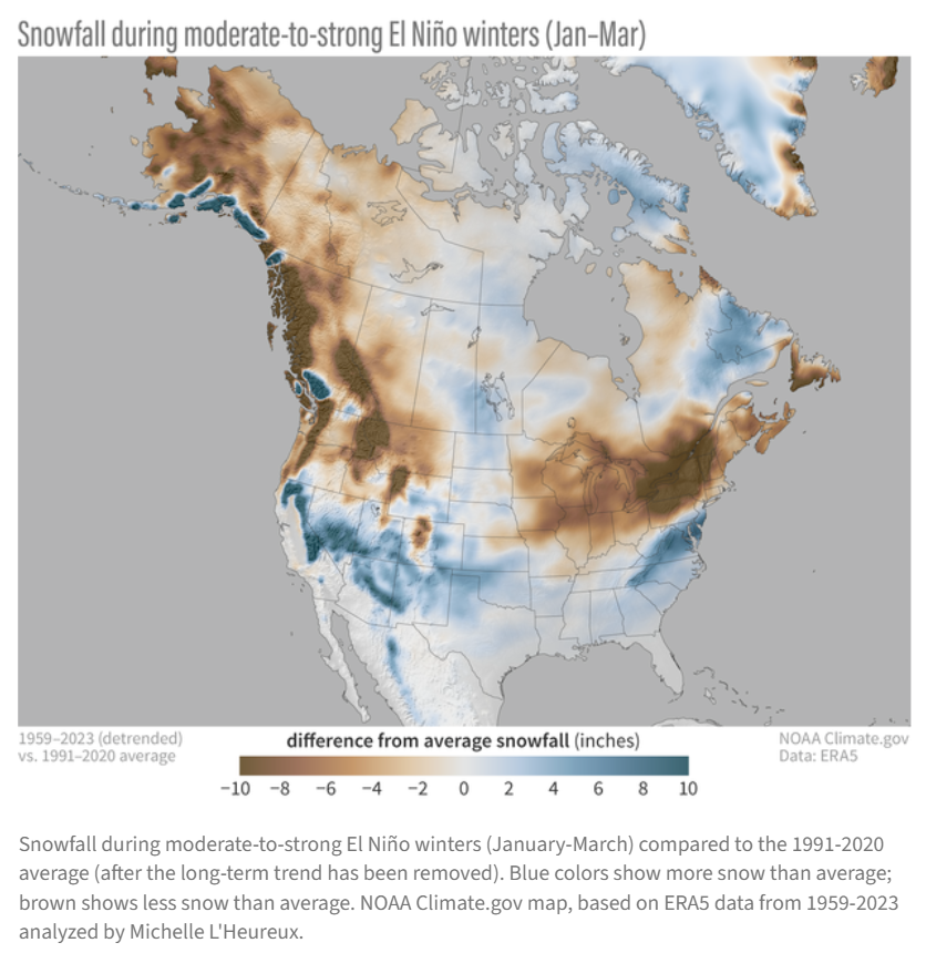
Image courtesy of Climate.gov
While the current forecast suggests a strong El Nino is likely during the 2026-27 winter season, it is far too early to determine an outcome for next winter. This is simply a sample of what past analogs suggest regarding a typical El NIno.
Other teleconnections that can affect the winter pattern include:
- North Atlantic Oscillation (NAO)
- Arctic Oscillation (AO)
- Pacific North American Pattern (PNA)
- Madden – Julian Oscillation (MJO)
While El Nino winters are typically notorious for fewer cold air outbreaks across the United States, cold air outbreaks and large winter storms can still occur. Changes in other atmospheric features such as the Polar Vortex can also play a role in our winter weather pattern.
The Bottom Line
The main takeaway is that a strong El Nino is currently expected to occur in the coming months across the eastern Pacific Ocean, and it could have substantial impacts on our local weather, not only this summer, but also as we head into the fall/winter.
For additional resources regarding El Nino, please refer to the Climate Prediction Center.
- https://www.cpc.ncep.noaa.gov/products/analysis_monitoring/enso_advisory/ensodisc.shtml
- https://www.weather.gov/fwd/basics
- https://www.weather.gov/fwd/indices
Leave a Reply