

A cold front will move across the Central Appalachian region this evening into the overnight, returning winter weather to much of the area. Impactful snow accumulation and frigid temperatures will be possible as Arctic air makes a return.
Here are a few of the key highlights and impacts:
- Rain will transition to snow Wednesday evening with the potential for a rapid freeze up.
- Snow accumulations are likely for most areas along and west of the Allegheny Front From Wednesday evening through Thursday.
- Snow squalls may lead to limited visibility and hazardous travel conditions on Thursday.
Rain Will Transition To Snow Wednesday Night With The Potential For A Rapid Freezeup
As a strong cold front moves eastward through the region Wednesday night, Arctic air will begin to rapidly push into the region. The front will be accompanied by rain that will transition to snow with the arrival of the colder air. The combination of water on roadways and temperatures quickly falling below freezing could cause a rapid freeze up Wednesday evening into Wednesday night.
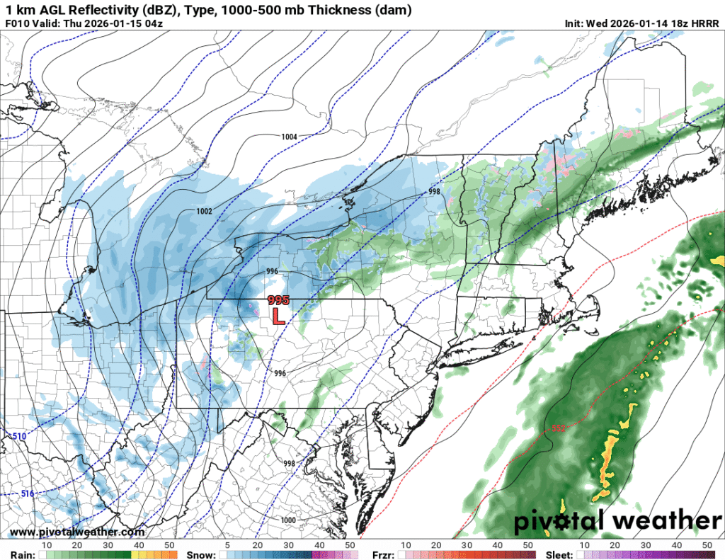
This image shows a depiction of surface reflectivity across the region late Wednesday evening based on 18z HRRR model guidance. Image courtesy of Pivotal Weather.
Snow Accumulations Are Likely For Most Areas Along And West of The Allegheny Front From Wednesday Evening Through Thursday
As the colder air arrives across the Central Appalachian region Wednesday evening, rain will transition to a period of snow. Warm surface temperatures may initially hinder snow accumulations at first, but snow will begin to accumulate on all surfaces through the night as below freezing temperatures move into the region. A quick accumulation of snow is likely Wednesday evening into the early overnight across many areas of eastern Ohio, northern West Virginia, and western PA before steady snow transitions to scattered snow showers through the remainder of the overnight hours.
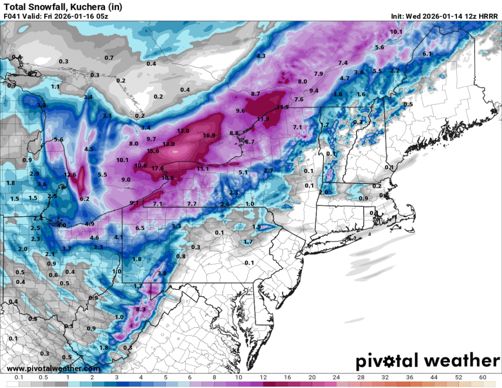
The image above shows a depiction of expected snow accumulation through Thursday evening based on 18z HRRR model guidance. Image courtesy of Pivotal Weather.
Additional snow showers and squalls on Thursday will lead to additional light accumulations for many areas. A storm total of 1 to 3 inches of snow is likely for many areas in the lowlands of western PA, eastern Ohio and northern West Virginia that are south and west of Pittsburgh. Areas north and west of Pittsburgh will likely see 2 to 4 inches. The higher elevation of western Maryland, northern West Virginia, and southwest PA will likely see 3 to 6 inches of total accumulation with isolated higher amounts possible.. Areas from northeast Ohio into western New York will likely see a more extended period of steady snow leading to heavier accumulations in the 6 to 12 inch range. Lake effect snow on Thursday will also aid in higher accumulations in this area. It is possible that amounts may be higher or lower in some areas depending on how much moisture overlaps with cold air Wednesday evening into the overnight The intensity and coverage of upslope and lake effect snow on Thursday will also have implications on snow totals.
Snow Squalls May Lead to Limited Visibility And Hazardous Travel Conditions On Thursday
As we move into the day on Thursday, there will be the potential for more snow showers and some snow squalls to develop for areas mainly along and west of the Allegheny Front. These snow squalls may be accompanied by heavy snow, limited visibility and gusty winds. Any heavy snow squalls that form can drop a quick light accumulation of snow in isolated areas.
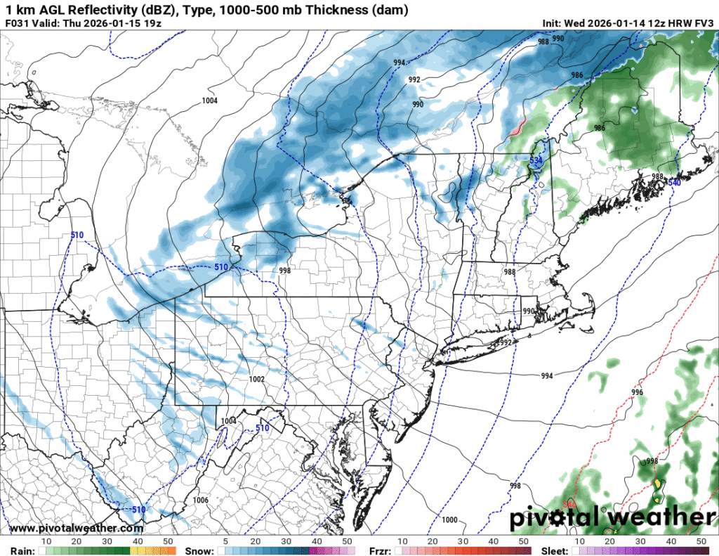
The image above shows a depiction of the surface reflectivity on Thursday afternoon based on 12z HRW FV3 model guidance. Image courtesy of Pivotal Weather.
More persistent lake effect snow will also be ongoing on Thursday in the typical lake effect regions downwind of Lake Erie. If you plan to travel during the day on Thursday, be sure to heed any snow squall warnings and delay travel until the snow squalls have passed your location.
Additional resources for additional information:
Leave a Reply